Firefighters battling West Coast blazes get good news, bad news from Mother Nature
Firefighters battling several wildfires across parts of the Northwest and northern California are getting a helping dose of rain Friday, thought it will likely come with the price of additional lightning.

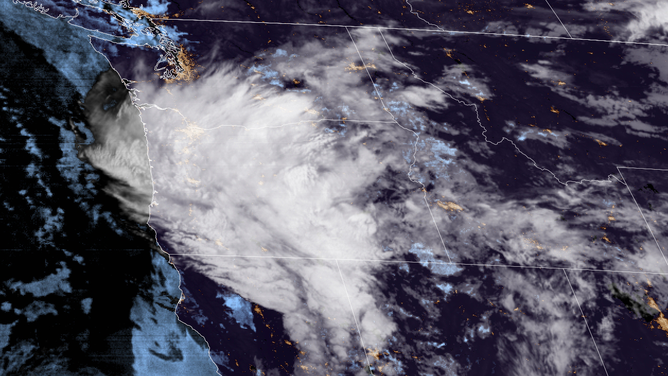
Satellite imagery shows a low pressure center over Oregon on Sept. 10, 2021
(NOAA / CIRA)
MEDFORD, Ore. -- Firefighters battling several wildfires across parts of the Northwest and northern California are getting a helping dose of rain Friday, thought it will likely come with the price of additional lightning.
A trough of low pressure is swirling across much of Oregon, triggering some showers and thunderstorms.
A few of the thunderstorms may end up with little to no rainfall (as it evaporates before it reaches the ground) meaning any lighting could have an easier time of triggering new wildfires. A Fire Weather Warning remained in effect for far northern California on the worry of additional lightning-triggered fires.
Incredible amount of lightning overnight https://t.co/VTk4GHL0fu
— Courtney Carpenter (@CourtECarpenter) September 10, 2021
But widespread light rain was reported across southern Oregon, including on top of wildfires burning there and in the Siskiyous area of California.
Some rainfall being observed this morning in Southern OR/Northern CA, mostly less than 0.1 inches thus far. A few cloud to ground flashes are accompanying showers in Siskiyou and Modoc Counties. More rainfall and better chance for lightning later this morning. #orwx #cawx pic.twitter.com/mJ2c5F2LG0
— NWS Medford (@NWSMedford) September 10, 2021
"The atmosphere also helped out the River Complex (Fire, in Northern California) by binging more substantial rainfall to that wildfire," said forecasters with the National Weather Service in Medford, Oregon. Forecasters also noted it appears the rain will remain light enough as to not trigger flash flooding concerns in areas where wildfires had previously burned vegetation.
Rain was expected at times through Friday across central and eastern Oregon, though forecasters warned as the day heats, showers could develop into thunderstorms with borderline severe thunderstorm conditions possible with strong winds and large hail. The Storm Prediction Center indicates a marginal risk (level 1 of 5) of severe weather along eastern Oregon into western Idaho and northern Nevada.
7:52am CDT #SPC Day1 Outlook Marginal Risk: over portions of the interior northwest to northern great basin https://t.co/GtEvHQ3UxE pic.twitter.com/Pk0b5juCC2
— NWS Storm Prediction Center (@NWSSPC) September 10, 2021
That brings the helpful rains, but also dangerous lightning and gusty winds that can fan flames of any existing or new fire starts.
But back in the beneficial column: The rains are expected to dampen the smoke output from existing fires in the region and air quality forecasts are showing some improvement for the weekend, though still not perfect:
A trough passage today will bring much needed rain and remove much of the smoke from the area. Thunderstorms will develop, mainly across SE Oregon, this afternoon for heavy rain and gusty outflow winds. #idwx #orwx pic.twitter.com/0lAH84NZ16
— NWS Boise (@NWSBoise) September 10, 2021
Air Quality Alerts remained in effect across much of Oregon, southern Idaho and Montana through at least Saturday morning.
Rainfall was expected through the day and then tapering off Friday night as the low pressure center blows off to the east.