Why 2023 hurricane outlooks run the gamut for how busy the season is expected to be
El Niños are known to suppress tropical activity in the Caribbean, Gulf of Mexico and Atlantic Ocean. NOAA said the impacts primarily stem from increased vertical wind shear, which can prevent tropical cyclones from forming and strengthening.
NOAA releases 2023 Atlantic hurricane season outlook
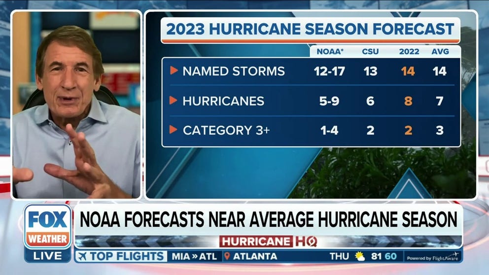
NOAA's Climate Prediction Center is predicting a near-average Atlantic hurricane season in 2023. FOX Weather hurricane specialist Bryan Norcross breaks down the latest hurricane season outlook released on Thursday
As the calendar ticks down to the official start of the 2023 Atlantic basin hurricane season, another tropical cycline outlook has been released by forecasters, which is helping shed light on just how complex the year’s weather patterns could be under an El Niño event.
The newest tropical weather outlook was released by the United Kingdom’s national weather service and calls for what could be a very active season in the Atlantic basin with around 20 named storms and 11 hurricanes. Just under half of the hurricanes could reach major status with winds that climb to at least 115 mph.
The outlook differs significantly from those that are calling for a season with activity that could be at or even below average.
Colorado State University was the first major institution to publicly release its outlook in April and called for a slightly below-average season. Its outlook called for a year with only 13 named storms, six hurricanes and around two major storms.
So, why the discrepancy?
Many weather forecasters say it is because of the emerging El Niño in the eastern and central Pacific Ocean.
An El Niño that is weaker and takes a long time to form could allow for several months of favorable conditions, while a stauncher event could lead to more reduced tropical activity.
El Niño patterns are known to suppress tropical activity in the Caribbean, Gulf of Mexico and Atlantic Ocean, but impacts vary.
"Forecasting an El Niño can be very challenging! If you get a weak El Niño and have a relatively warm tropical Atlantic, you can still get a very busy Atlantic hurricane season. However, historically when El Niño events have exceeded 1.0 °C warmer than normal, these seasons have typically been below average for Atlantic seasonal hurricane activity," Phil Klotzbach, lead author of the CSU outlook, stated.
HERE’S WHAT AN EL NINO CLIMATE PATTERN IS
UK meteorologists agree that an El Niño will be in control of weather patterns during the usual heart of the Atlantic basin hurricane season, but they expect differences between a classic event and the 2023 El Niño.
"Vertical wind shear through the troposphere over the tropical Atlantic is predicted to be lower than previously seen during El Niño events. Sea surface temperatures are predicted to remain well above average across the tropical North Atlantic during the whole hurricane season," UK Met forecasters said in their outlook.
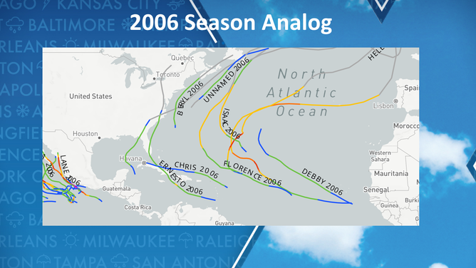
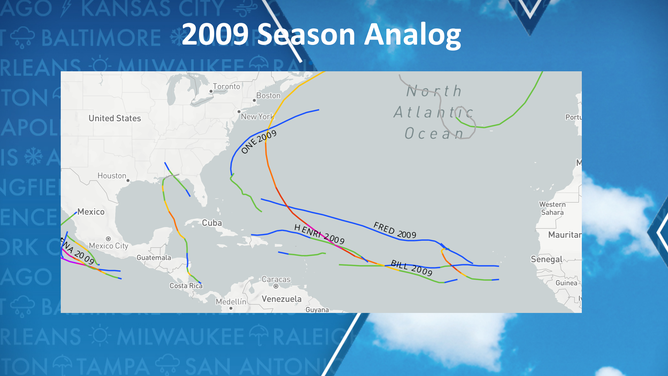
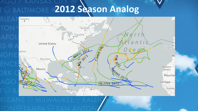
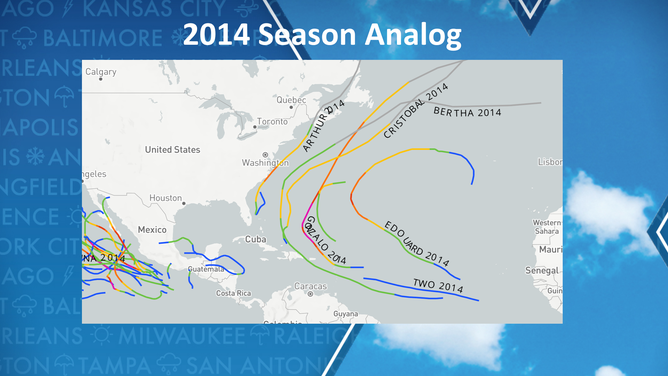
Seasons that CSU experts are using to compare 2023 activity to include 1969, 2002, 2004, 2006, 2009, 2012, 2014 and 2015.
![1969 Hurricane season tracks]() Image 1 of 8
Image 1 of 81969 Hurricane season tracks ( )
![2002 Hurricane season tracks]() Image 2 of 8
Image 2 of 82002 Hurricane season tracks ( )
![2004 Hurricane season tracks]() Image 3 of 8
Image 3 of 82004 Hurricane season tracks ( )
![2006 Hurricane season tracks]() Image 4 of 8
Image 4 of 82006 Hurricane season tracks ( )
![2009 Hurricane season tracks]() Image 5 of 8
Image 5 of 82009 Hurricane season tracks ( )
![2012 Hurricane season tracks]() Image 6 of 8
Image 6 of 82012 Hurricane season tracks ( )
![2014 Hurricane season tracks]() Image 7 of 8
Image 7 of 82014 Hurricane season tracks ( )
![2015 Hurricane season tracks]() Image 8 of 8
Image 8 of 82015 Hurricane season tracks ( )
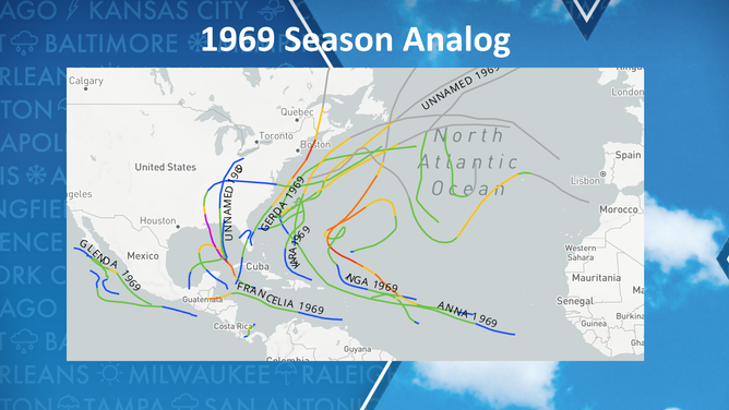
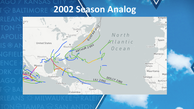
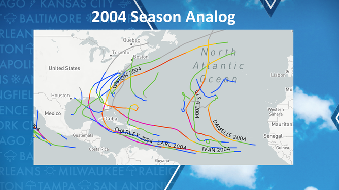
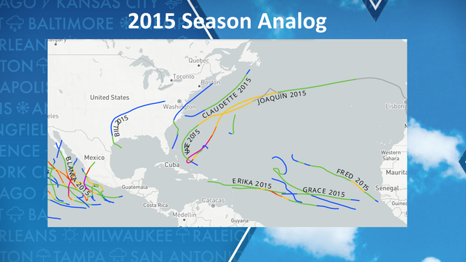
The 2015 season only produced 11 named storms, with minimal impacts to the U.S., but the 2004 season was historic, with over half a dozen significant cyclones that impacted the Southeast alone.
"The range of seasonal outcomes vary vastly between these years. Once we get a better idea of how strong a potential El Niño is going to be and how warm the tropical Atlantic is, we can fine-tune our analogs," Klotzbach said.
NEAR-AVERAGE 2023 ATLANTIC HURRICANE SEASON EXPECTED WITH UP TO 17 NAMED STORMS, NOAA SAYS
NOAA considers predicting the impacts El Niño and La Niña have on hurricane activity to be a challenge and warns that outlooks released during the spring have limited skill.
The agency puts the odds of entering an El Niño over the summer at 93% and believes the pattern could be in control through the rest of the year and into 2024.
This outcome would result in the majority of the Atlantic basin hurricane season being influenced by an El Niño, but its direct impacts on cyclones are still up for debate among the world’s leading climatological agencies.
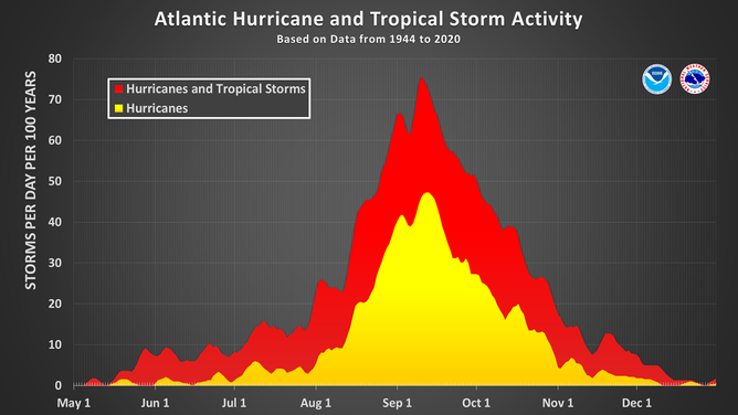
This chart shows the amount of tropical cyclone activity, in terms of named storms and hurricanes, that occurs in the Atlantic Basin on each calendar day between May 1 and Dec. 31. Specifically, it shows the number of hurricanes (yellow area) and the combined named storms and hurricanes (red area) that occur on each calendar day over a 100-year period. The chart is based on data from the 77-year period from 1944 to 2020 (starting at the beginning of the aircraft reconnaissance era) but normalized to 100 years. The official hurricane season for the Atlantic Basin is from June 1 to Nov. 30, but tropical cyclone activity sometimes occurs before and after these dates, respectively. The peak of the Atlantic hurricane season is Sept. 10, with most activity occurring between mid-August and mid-October.
(National Hurricane Center / NOAA)