Dust from Sahara Desert brings milky haze to Florida's skies
The plumes can reach high into the atmosphere, where the easterly trade winds will eventually carry the dusty, dry air 3,000 miles west across the Atlantic Ocean.
ORLANDO, Fla. -- The sunshine in the Sunshine State had some competition in the skies Wednesday morning as dust from the Sahara desert has blown across the Atlantic, bringing a milky haze.
The Saharan dust is in full force across Florida this morning! Notice that hazy sky? It’s particles of sand/dust from the Sahara desert blown in from mighty wind storms. #flwx #FOX35 pic.twitter.com/O8OYnyZUah
— Brooks Garner FOX 35 (@BrooksWeather) August 25, 2021
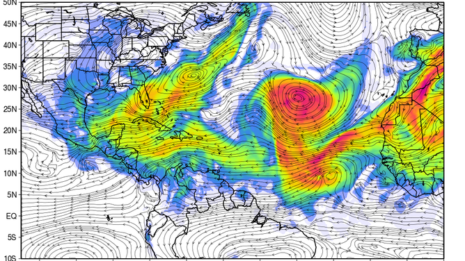
The phenomenon happens a few times a year. It begins when the blistering summer heat in the Sahara causes air to rise and carry the dust and sands along for the ride. The plumes can reach high into the atmosphere, where the easterly trade winds will eventually carry the dusty, dry air 3,000 miles west across the Atlantic Ocean.

NASA forecast map showing predicted dust across the eastern U.S. and Atlantic Ocean.
The visual effects are to make for a milky or hazy sky, many times giving a dramatic color to the sunrise and sunset. But if the dust settles low enough, it can degrade air quality and cause eye or throat irritations, or even breathing problems to those sensitive enough.
In this case, it's also having a mild effect on the weather itself. The weather balloon launched from Tampa, Florida Wednesday morning showed a layer of dry air in the lower atmosphere -- caused by the dry desert wind blowing in from the Sahara.
The Saharan Dust - which is called the Saharan Air Layer, or SAL for short - dries out the atmosphere in the layer where it is present. In the annotated section of this morning’s balloon data, the red line (temp), and green line (dew point) diverge, meaning the air is drier pic.twitter.com/MFtsIfsnK4
— NWS Tampa Bay (@NWSTampaBay) August 24, 2021
National Weather Service forecasters in Tampa say the dry air isn't enough to limit their typical summertime thunderstorm developments Wednesday, but could affect timing and strength.
"It is likely to keep storms from firing until later in the afternoon, and they may be a bit stronger with drier air, but our rain chances still look pretty typical today," forecasters said.
Dust can have actually have benefits to the region as well. That dry Saharan desert air tends to limit hurricane development in the Atlantic Ocean, though the tropics are starting to get a bit active anyway.