Developing tropical system could threaten US Gulf Coast early next week
The National Hurricane Center says there's a high chance of tropical development
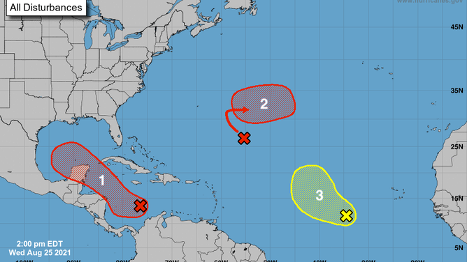
The tropical weather outlook issued by the National Hurricane Center at 2 p.m. Eastern on Aug. 25, 2021.
(NOAA/NHC)
Residents of the U.S. Gulf Coast should closely monitor forecasts in the days ahead as a developing tropical system heads in the direction of the Gulf of Mexico.
The National Hurricane Center is monitoring three areas in the Atlantic Basin for potential development over the next five days, which is not unusual for the end of August because the climatological peak of hurricane season is just over two weeks away on Sept. 10.
However, one of the areas being monitored by the NHC is more concerning than the others. The next named storms in the Atlantic will be called Ida, Julian and Kate, respectively.
Disturbance No. 1: Invest 99L
As of Wednesday afternoon, a tropical wave – dubbed Invest 99L by the NHC – was located over the south-central Caribbean Sea.
An invest is a naming convention used by the NHC to identify areas it is investigating for possible development into a tropical depression or tropical storm within the next five days.
The NHC said this tropical wave is expected to develop into a broad area of low pressure over the southwestern Caribbean Sea during the next day or two.
Environmental conditions in that part of the Caribbean are forecast to be conducive for tropical development, so the NHC has given this system a high chance of development into a tropical depression or tropical storm late this week or over the weekend as it moves northwestward over the northwestern Caribbean Sea.
On Saturday, the system is predicted to move near or across Mexico's Yucatan Peninsula, then into the western Gulf of Mexico by Sunday. Once it enters the Gulf, environmental conditions are expected to be favorable for further development into early next week.
Regardless of development, heavy rainfall and flooding will be possible through this weekend in portions of Nicaragua, Honduras, Guatemala, Belize and the Yucatan Peninsula.
From there, the forecast gets a bit more uncertain. Some computer models take this system on a more westerly path toward northern Mexico, but others suggest it will track more northwestward toward the western Gulf Coast of the U.S. between Texas and Louisiana.
The system's exact track will be dependent on the position and strength of an area of high pressure over the southern United States.
"This system could bring dangerous impacts from storm surge, wind and heavy rainfall to portions of the coasts of Louisiana, Texas and the Mexican state of Tamaulipas late this weekend and early next week," the NHC said in its tropical weather outlook Wednesday afternoon. "However, uncertainty remains large since the system has yet to form. Interests in these areas should closely monitor the progress of this system and ensure they have their hurricane plan in place."
The bottom line is that the potential exists for a tropical storm or even a hurricane approaching the western Gulf Coast early next week, but it's far too early to make an accurate prediction on the system's exact track and potential impacts. If you live in this region, it's best to closely monitor forecasts over the next few days.
Disturbance No. 2: Invest 97L
A broad area of low pressure – dubbed Invest 97L by the NHC – was producing disorganized showers and thunderstorms over the central tropical Atlantic Ocean about 700 miles southeast of Bermuda as of Wednesday afternoon.
According to the NHC, only slow development of this system is expected over the next day or two because of unfavorable upper-level winds.
However, environmental conditions are forecast to become more conducive for tropical development later this week, so the NHC has given this system a high chance of development into a tropical depression by late week or this weekend as it turns eastward over the central Atlantic.
It is not expected to threaten any land areas over the next several days, but it might eventually pass near the Azores.
Disturbance No. 3: Invest 98L
As of Wednesday afternoon, a tropical wave – dubbed Invest 98L by the NHC – was producing an area of disorganized showers and thunderstorms several hundred miles southwest of the Cabo Verde Islands.
The NHC said some development of this system is possible over the next several days as it moves west-northwestward across the eastern tropical Atlantic Ocean.
However, upper-level winds are expected to become less conducive for tropical development by early next week, so the NHC only gives it a low chance to develop into a tropical depression.
No land areas are expected to be affected by this system over the next several days.
Check back to FOX Weather for updates on all three systems in the days ahead.