Downpours target I-95 corridor in mid-Atlantic with flash flood threat Tuesday
According to the FOX Forecast Center, a moist, onshore flow will support persistent showers and thunderstorms across portions of North Carolina and the southern mid-Atlantic on Tuesday.
Midweek washout possible for parts of East Coast
A coastal low, previously labeled as Potential Tropical Cyclone Eight, will continue to slowly move north across the Carolinas towards the mid-Atlantic over the next day or so.
A coastal low, previously labeled Potential Tropical Cyclone Eight, will continue to slowly move north across the Carolinas towards the mid-Atlantic over the next day or so and bring with it the potential for flooding.
According to the FOX Forecast Center, a moist, onshore flow will support persistent showers and thunderstorms across portions of North Carolina and the southern mid-Atlantic on Tuesday, and locally heavy rainfall could result in some instances of flash flooding.
NORTH CAROLINA CLOBBERED WITH HISTORIC RAIN AS POTENT NON-TROPICAL STORM MOVED ONSHORE

(FOX Weather)
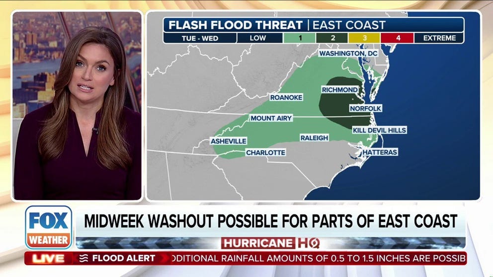
Flood Watches are in effect for portions of southeastern Virginia and North Carolina. Parts of the Interstate 95 corridor in the mid-Atlantic are highlighted for a Level 2 out of 4 risk of flash flooding on Tuesday.

(FOX Weather)
Precipitation coverage and intensity should decrease Wednesday, as the area of low pressure moves off the mid-Atlantic coast. If the low stays close enough to land, it'll at least bring soaking rain to the Tri-State area.
Coastal flooding will also be a concern with a prolonged period of onshore winds along the mid-Atlantic coast. Minor to perhaps moderate coastal flooding is expected during high tide. The Thursday afternoon high tide is the most likely to see widespread flooding.
Record rainfall floods North Carolina following Monday's coastal storm
It never got a name, but for residents along the coast of southeast North Carolina, this storm, formerly known as Potential Tropical Cyclone Eight, will be one they won't forget. The coastal storm dropped historic rain with some places picking up more than 18 inches in less than 12 hours. This led to damaging flooding in numerous communities.
Will Boston get any rain?
Boston is currently in the midst of its longest dry stretch in 25 years. It hasn't seen rain since Aug. 20. Tuesday will bring it into a tie for the fifth-longest dry stretch on record.
The official FOX Weather forecast says Boston could break that streak with rainfall possible between Wednesday night and Thursday.

(FOX Weather)

