Detroit, Indianapolis amid over 30 million covered in Saturday severe weather threat
Severe thunderstorms were already rumbling in the predawn hours across Iowa on Saturday morning and were advancing eastward, putting cities including Des Moines, Chicago and Indianapolis in the potential path later in the day.

Chicago, Detroit amid over 40 million inside severe weather risk Saturday
The weekend is kicking off on a stormy note across the Upper Midwest with severe thunderstorms and flash flooding a risk across several metro areas, including Chicago and Detroit.
INDIANAPOLIS – The FOX Forecast Center is monitoring a large swath of the Midwest and Great Lakes region for the potential development of severe thunderstorms to kick off the weekend, with damaging winds, hail and even a few tornadoes as a plume of storms moves east Saturday.
So far by midday Saturday, the storms have had minimal impact, with just a handful of Flash Flood and Severe Thunderstorm Warnings, though radar indicated one potential tornado in central Iowa earlier Saturday morning, triggering a Tornado Warning. A gust on a private weather station hit 59 mph just north of Des Moines, according to the NWS.

Tornado sirens wail as severe storms move through Iowa
Severe weather blew through central Iowa Saturday morning, triggering Tornado Warnings.
Street flooding was observed in Vinton, Iowa and over in Chicago, both O'Hare and Midway airports were put into a groundstop as the batch of thunderstorms swept through.
Highway 50 was covered in water in multiple spots near Flora, Illinois, and "significant" flooding was reported in Cisne, Illinois with sandbagging efforts under way, NWS spotters reported.
Over in Indiana, flash flooding blocked multiple roads in Decker and Winslow.

(FOX Weather)
Despite limited action so far for severe-level thunderstorms, NOAA’s Storm Prediction Center has maintained a wide area of a Level 2 of 5 risk for severe storms into Saturday evening. Detroit, Indianapolis and Cincinnati are major cities still within this threat zone as storms may get more active into the afternoon and evening.

(FOX Weather)
Two other areas of severe weather threaten Plains, mid-Atlantic
In addition to the Upper Midwest and Great Lakes, two other swaths of the nation are under threat of severe weather to kick off the weekend.
Farther west, a line of potentially strong thunderstorms stretches from eastern Montana, through the western Dakotas and into western Nebraska. While damaging wind gusts and a few isolated tornadoes are possible, the most significant threat is large hail – of baseball size or even larger.
The large hail threat zone covers cities such as Rapid City, South Dakota; North Platte, Nebraska and Sturgis, South Dakota.

(FOX Weather)
Along the Eastern Seaboard, the Storm Prediction Center has highlighted a swath of Virginia and northern North Carolina for potentially damaging winds amid severe thunderstorms Saturday. The risk zone includes Richmond and the Norfolk/Hampton Roads area.
Flash flooding risk covers several states in the East
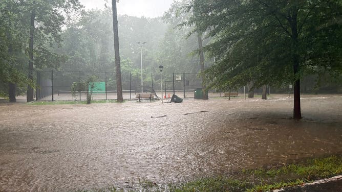
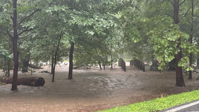
Storms outside the higher-risk zones caused problems in central Maryland with Flash Flood Warnings and a Flash Flood Emergency being issued outside Washington, D.C.
Areas such as Bethesda, Takoma Park, Chevy Chase, Silver Spring and Wheaton in Maryland were placed under a Flash Flood Emergency after 3-5" of rain fell with an additional 2-4" on the way.
Several water rescues were reported in Montgumery County, Maryland but during the intimal hours of the event there were no reported injuries or missing people.
![Flooding reported in central Maryland on 7/19/2025]() Image 1 of 2
Image 1 of 2Flooding reported in central Maryland on 7/19/2025 (Maryland-National Capital Park Police)
![Flooding reported in central Maryland on 7/19/2025]() Image 2 of 2
Image 2 of 2Flooding reported in central Maryland on 7/19/2025 (Maryland-National Capital Park Police)