Bryan Norcross: A calm week in the tropics; still watching the waters around Bermuda
There’s a slight chance an elongated area of non-tropical disturbed weather, a dip in the jet stream, and perhaps a dash of moisture from the remnants of Tropical Storm Cindy will come together to develop a system with at least some tropical characteristics.

Generic Hurricane HQ
(FOX Weather)
Updated at 9 a.m. EDT
Saharan dust continues to do its job over the tropical Atlantic while a band of hostile upper winds stretches across the ocean just north of the tropical belt. Together, they should keep the tropics calm for the next week at least.
The weather pattern is still complex around Bermuda. There’s a slight chance an elongated area of non-tropical disturbed weather, a dip in the jet stream, and perhaps a dash of moisture from the remnants of Tropical Storm Cindy will come together to develop a system with at least some tropical characteristics.
Even if it happens over the next few days, there is no indication it would become very strong or pose a significant threat to land.
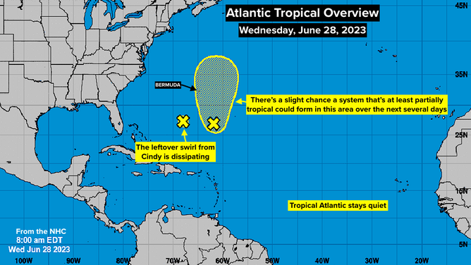
Atlantic tropical overview.
(FOX Weather)
The swirl that was leftover from the core of Cindy has mostly dissipated. The lefthand "X" of the map above is the approximate location of the last hint of what was the tropical storm.
The yellow area around and north of Bermuda is where computer forecast models indicate that an area of low pressure could develop, but the National Hurricane Center is giving it a low chance of becoming a tropical system, even if it does come together.
For now, we’re looking good.
FOX Weather Hurricane Specialist Bryan Norcross has a podcast, Tracking the Tropics with Bryan Norcross, available now on FOX News Audio. You can get it on your device by clicking here.