Central American Gyre creates tropical threats, part of seasonal weather pattern shift
The disturbance spun off what forecasters call the Central American Gyre, or CAG. The CAG typically becomes more active during the latter half of October and is responsible for many of the tropical systems that make landfall in the U.S., as well as tropical systems in the Eastern Pacific Ocean toward the end of hurricane season.

National Hurricane Center monitoring area to watch in the Gulf as Central American Gyre develops
The National Hurricane Center (NHC) said Wednesday that a disorganized area of showers and storms could develop as it moves across Mexico's Bay of Campeche through Wednesday. Meteorologists have given the disturbance a low chance of developing. The disturbance has spun off what forecasters call the Central American Gyre. The broad area of low pressure typically develops once or twice during the early and late months of hurricane season.
MIAMI – A disturbance off Central America that was highlighted for the possibility of tropical development over the Bay of Campeche has moved onshore and is no longer being monitored for development into a tropical system.
The National Hurricane Center (NHC) said that a disorganized area of showers and storms is now bringing rain and gusty winds to southern Mexico.
The disturbance spun off what forecasters call the Central American Gyre, or CAG.

(FOX Weather)
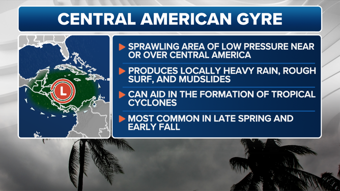
What is the Central American Gyre?
The CAG typically becomes more active during the latter half of October and is responsible for many of the tropical systems that make landfall in the U.S., as well as tropical systems in the Eastern Pacific Ocean toward the end of hurricane season.
The broad area of low pressure typically develops once or twice during the early and late months of hurricane season.
A CAG can trigger a range of hazardous weather besides tropical cyclones, including torrential rain, flooding and mudslides.
DOWNLOAD THE FREE FOX WEATHER APP
Central American Gyre
(FOX Weather)
About once every other year, a tropical cyclone emerges from one of these gyres and strengthens into a hurricane if atmospheric conditions allow.
Some of the most notable examples include Hurricane Michael (2018), which struck the Florida Panhandle as a Category 5 hurricane after spending days embedded in a CAG. Tropical storms Amanda and Cristobal, both in 2020, also developed from similar setups, as did Tropical Storm Andrea in 2013 and Hurricane Ida in 2009.