Winds at or near hurricane strength forecast for parts of Puerto Rico, Dominican Republic
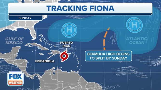
The consensus of the best computer forecast models, which is reflected in the National Hurricane Center forecast, is that the center of the storm will track near the Mona Passage, the gap between Punta Cana in the Dominican Republic to the west and Puerto Rico to the east on Monday.
The podcast Tracking the Tropics with Bryan Norcross is now available to stream.
(FOX Weather)
Updated at 8:25 a.m. Eastern
Tropical Storm Fiona is still a ragged-looking system but shows signs of slow intensification. It will track well to the south of the Virgin Islands today, but slowly begin a bend to the north. The consensus of the best computer forecast models, which is reflected in the National Hurricane Center forecast, is that the center of the storm will track near the Mona Passage, the gap between Punta Cana in the Dominican Republic to the west and Puerto Rico to the east on Monday.
Fiona’s disorganization has been caused by the dry atmosphere ahead of the storm being blown into the circulation by moderately hostile upper winds. Those dry winds have tilted the circulation and dried out half the storm. On its trek across the Caribbean south of the Virgin Islands and Puerto Rico, Fiona is forecast to slow down. The high pressure that’s been pushing it along is losing its influence. That slowdown and slightly less hostile upper winds should allow continued slow strengthening for the next couple of days.
As Fiona approaches the southwest coast of Puerto Rico or the eastern part of the Dominican Republic, it is forecast to be at or near hurricane strength. Hurricane Watches have been issued for Puerto Rico and the eastern D.R. because of this possibility.
HOW TO WATCH FOX WEATHER ON TV
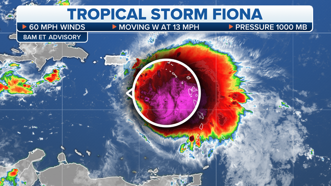
Tropical Storm Fiona is still a ragged-looking system but shows signs of slow intensification.
(FOX Weather)
The worst weather in Fiona’s circulation is on the back side of the storm – the right side. While it is likely to wrap up to some degree, with more strong winds close to the center, the storm will likely still be east-side loaded when it approaches Puerto Rico and the eastern Dominican Republic. This means, if the forecast track is correct, more moisture will be flung against the mountains of Puerto Rico, which would result in very heavy rainfall.
The National Hurricane Center is forecasting 5 to 10 inches of rain on Puerto Rico with some areas receiving up to 16 inches. If anything like these numbers hold up, mudslides and flooding will be a significant threat.
Since it’s very likely that Fiona will track south of the island, the biggest impact on Puerto Rico will be in the eastern and especially the southern sections. If Fiona tracks through or near the Mona Passage, Mayaguez on the island's western end would also feel very strong winds and heavy rain. The mountains will somewhat protect San Juan on the northern coast if Fiona stays on or near the projected track.
Fiona’s disorganization has been caused by the dry atmosphere ahead of the storm being blown into the circulation by moderately hostile upper winds.
(FOX Weather)
On the west side of the Mona Passage, Punta Cana in the Dominican Republic and nearby mountainous areas must also prepare for a direct hurricane hit, including significant rainfall and high winds.
The longer-range computer forecast models have come into good agreement on the forecast track, so there is reasonably high confidence in the general idea of Fiona crossing into the Atlantic near the Mona Passage, plus or minus. The Turks and Caicos and the southeastern Bahamas will need to stay in close touch with the latest information because they could feel the direct effects of Fiona once it moves into the Atlantic.
The rest of the Bahamas and the U.S. East Coast appears to be in the clear. A strong dip in the jet stream should scoop up Fiona and push it out to sea. Bermuda appears to be the only land area that might be affected farther north.
Elsewhere in the Atlantic, the National Hurricane Center is noting two disorganized disturbances. Each has a slight chance of developing, but neither would threaten land.
Otherwise, nothing appears to be pending.
FOX Weather Hurricane Specialist Bryan Norcross has a podcast, Tracking the Tropics with Bryan Norcross, available now on FOX News Audio. You can get it on your device by clicking here.