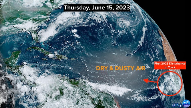
Bryan Norcross: First disturbance of interest this hurricane season is moving off Africa
The NHC is giving this new system a 20% chance of developing into at least a tropical depression over the next week.

Tracking a new tropical disturbance in the Atlantic
FOX Weather Hurricane Specialist Bryan Norcross explains why the tropical wave off Africa is worth watching for development. The system has a 20% chance of development in the next week, according to the National Hurricane Center.
For the first time this year, the National Hurricane Center is making note of an African disturbance that's just moving into the Atlantic. It's normal for systems to move off Africa by this time of the year, though it's unusual for the atmospheric and ocean environment to appear somewhat conducive for the system to organize.
The record book lists only three systems that have organized in this potential development zone in June. The most recent one was Elsa in 2021, which became a hurricane before moving through the Caribbean and eventually affecting the west coast of Florida. Although, the system that would become Elsa was only a tropical depression in June. Tropical Storm Elsa didn't develop until July 1.
(NOAA)
The NHC is giving this new system a 20% chance of developing into at least a tropical depression over the next week.
The potential development areas for systems moving across the Atlantic are longer this year because the time window has been stretched from 5 to 7 days. Since there's a low chance the system will organize at all, the zone where development would occur, if it does, follows where the system is forecast to track over the next 7 days.
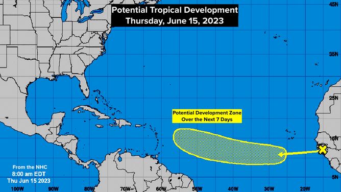
The National Hurricane Center is tracking a wave off the coast of Africa with a 20% chance of development in 7 days.
(NOAA)
The X on the graphic indicates where the nominal center of the system is now. The line over the ocean shows that the disturbance is not expected to have a chance to organize immediately, but after a couple of days, the possibilities increase slightly.
The ocean is extremely warm, which means the system has more fuel than usual for thunderstorms to develop. Thunderstorm development is a key step in a tropical system's organizational process.
There is a lot of dry air just to the north of where the disturbance is forecast to track, which is one of the factors keeping the odds of development low. We'll see if the very warm ocean moistens the atmosphere immediately around the disturbance mid-next week, so it can hold off the dry air.
Looking downstream, the atmospheric pattern is currently totally hostile to any tropical systems approaching Florida or the East Coast of the U.S. But we'll keep an eye on it as the disturbance treks across the Atlantic to be sure it doesn't misbehave.