Bryan Norcross: What's left of Tropical Storm Philippe forecast to menace New England this weekend
Philippe has been one of the most poorly behaved storms in recent memory. Our fancy modern computer forecast models have been stunningly unable to get a grip on the combination of a discombobulated storm, other nearby storms and disturbances, and medium-strong upper-level winds. And the drama is not over.

FOX Weather is your Hurricane HQ, streaming free 24/7.
(FOX Weather)
Updated at 9:30 a.m. EDT on Wednesday
The forecasting nightmare that is Tropical Storm Philippe is not finished being a problem. The system is only loosely structured like a tropical storm. Its center of circulation has moved into the Atlantic north of the Caribbean. But tropical squalls with heavy rain and gusty winds are still impacting Puerto Rico and the U.S. and British Virgin Islands just to the east.
Philippe has been one of the most poorly behaved storms in recent memory. Our fancy modern computer forecast models have been stunningly unable to get a grip on the combination of a discombobulated storm, other nearby storms and disturbances, and medium-strong upper-level winds. And the drama is not over.
Philippe will continue to move north in the direction of Bermuda today, dragging its blob of heavy thunderstorms with it. An elongated channel of moisture will follow the system, however – a moisture tail – which will continue to cause periods of heavy rain over Puerto Rico and the surrounding islands into the weekend.
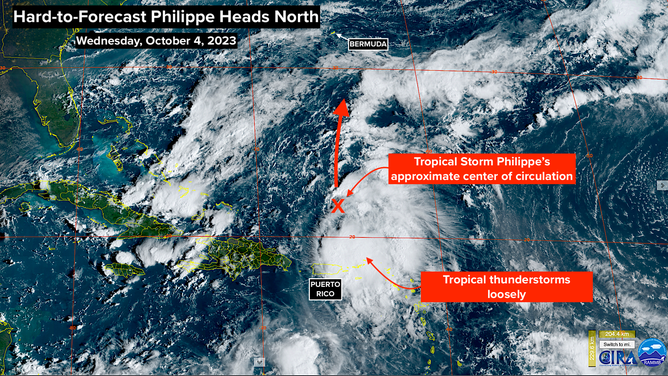
A satellite image of Tropical Storm Philippe on Wednesday, October 4, 2023.
(NOAA)
Philippe's move to the north is being directed by a large non-tropical disturbance east of Florida, which is related to the cold front that moved down the state this week, and high pressure over the central Atlantic. Between them, there is a channel of air heading north. But since this is Philippe, nothing is simple.
Some computer forecasts predict that a non-tropical low-pressure system related to the disturbance off Florida will form just east of Philippe in a couple of days, which could cause the tropical storm to zig and zag when it's in the vicinity of Bermuda. In any case, the island should be ready for tropical storm conditions when Philippe and the non-tropical low move by on Friday.
Then another complex phase of Philippe's life begins.
A giant, powerful, winterlike disturbance is forecast to develop over the Great Lakes late this week, which will create an atmospheric channel from south to north offshore of the Northeast U.S. Both Philippe and the non-tropical low will be pulled north in that strong river of air. The current thinking is that the orientation of the channel will be toward northern New England or Atlantic Canada, though the exact geometry of the complex pattern is uncertain.
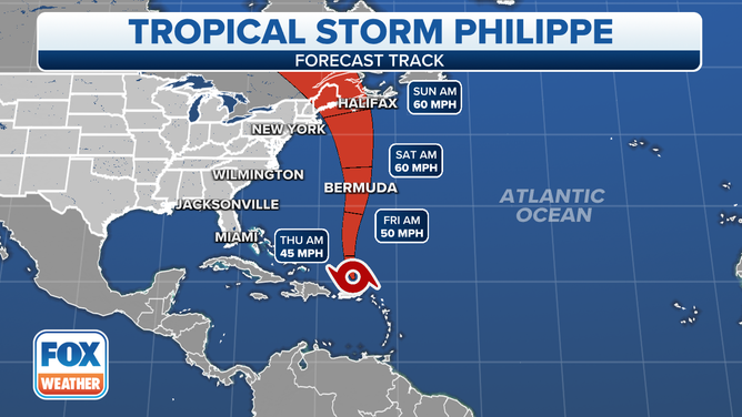
The forecast track of Tropical Storm Philippe.
(FOX Weather)
How Philippe will co-exist with the non-tropical low is also fuzzy. Likely, they will merge into a strong non-tropical low-pressure system at some point, but they might co-exist for a while and affect each other's tracks. In any case, the giant Great Lakes disturbance will increasingly supply the energy to power the system or systems, so Philippe is likely to morph from a tropical storm into more-or-less a nor'easter.
The bottom line is that onshore winds should start to increase on the New England coast on Friday with a strong coastal storm, which includes what's left of Philippe, impacting northern New England and Atlantic Canada Saturday into Sunday. Yes, this is the same area impacted by Hurricane Lee just two and a half weeks ago.
Strong winds will affect much of the Northeast, but for areas south of Boston, the wind will be coming from the northwest, off the land. Only areas north of where the combo low-pressure system containing what's left of Philippe comes ashore will get the strong onshore flow, which will cause some storm surge along the coast.
In addition, a combination of the cold front associated with the giant Great Lakes disturbance and Philippe is forecast to bring periods of heavy rain to parts of the Northeast and New England late in the week and over the weekend.
The combo low-pressure area should move north into Canada by late Sunday, which will usher in a dramatic improvement to the weather.
No other threats are immediately evident, although a late-season disturbance might move off Africa around the weekend. There's no sign of it being a problem at this time, however.