Watching a new tropical disturbance heading toward the Caribbean
Tropical disturbance #1 appears to have a decent circulation in the Central Atlantic in the mid-levels of the atmosphere, but it is just in the development stages.
The podcast Tracking the Tropics with Bryan Norcross is now available to stream.
(FOX Weather)
There are two tropical disturbances on the map – one of no consequence and one we’ll keep an eye on.
Tropical disturbance #1 is a large cluster of thunderstorms in the Central Atlantic Ocean about 900 miles east of the Caribbean Islands. It appears to have a decent circulation in the mid-levels of the atmosphere, but it is just in the development stages.
The atmospheric environment looks reasonably conducive for the system to organize, though somewhat less so when the disturbance gets to the Caribbean. For now, the National Hurricane Center is giving it a low chance of developing into a tropical depression over the next 5 days.
HOW TO WATCH FOX WEATHER ON TV
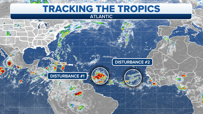
A map showing two tropical disturbances in the Atlantic Ocean.
(FOX Weather)
Once the system gets in the Caribbean around Thursday, a blocking high-pressure system is forecast to build to its north across the large Caribbean islands and southern Florida. This should keep the disturbance, or whatever it is at that point, moving west through the Caribbean Sea this week at least.
As we’ve discussed many times, forecasts for disorganized or just-developing systems are subject to larger-than-normal changes. That applies in this case.
Tropical Disturbance #2 is in the far eastern Atlantic near Africa. A patch of conducive environment appears likely to allow it to develop into a tropical depression or tropical storm. It will get the name Tropical Storm Julia if winds reach at least 40 mph. In any case, it is forecast to immediately move to the north and not be of consequence.
We’ll keep an eye on Tropical Disturbance #1, but there is no threat to the U.S at this time.
FOX Weather Hurricane Specialist Bryan Norcross has a podcast, Tracking the Tropics with Bryan Norcross, available now on FOX News Audio. You can get it on your device by clicking here.