Bryan Norcross: Tropical Storm Watches may be issued for Caribbean islands today for Invest 94L
On the current schedule, winds from possible Tammy could start affecting the islands as soon as late tomorrow. So if the current trends continue, the National Hurricane Center could declare the system a potential tropical cyclone and issue watches today.

FOX Weather is your Hurricane HQ, streaming free 24/7.
(FOX Forecast Center / FOX Weather)
Updated Wednesday at 9:30 a.m. EDT
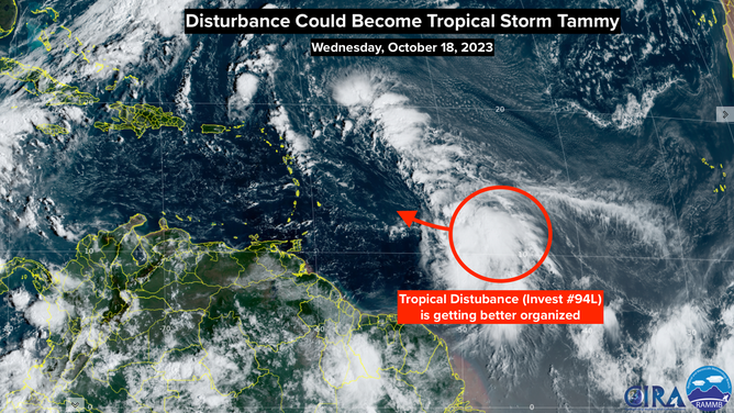
The Atlantic tropical disturbance officially called Invest 94L is organizing. The large cluster of thunderstorms is covering the apparent center of the system, so it’s unclear whether there is a well-defined circulation, but it’s getting closer.
Hurricane Hunters are scheduled to fly into the system tomorrow morning to get a good look at what’s going on under the clouds.
By satellite, winds have been measured between 35 and 40 mph on the northeastern side of the nominal center. If they reach 40 mph and there is a defined circulation, the disturbance will be named Tropical Storm Tammy.
On the current schedule, winds from possible Tammy could start affecting the islands as soon as late tomorrow. So if the current trends continue, the National Hurricane Center could declare the system a potential tropical cyclone and issue watches today.
Potential tropical cyclone is a confusing name, but think of it as a potential tropical threat. It means the system could develop into a tropical depression or tropical storm before it reaches land. Because that could happen in two days or less, Tropical Storm Watches are required to alert people to get ready, even though the system isn’t yet named.
NOAA satellite imagery of Invest 94L.
(NOAA)
The consensus of the various computer forecasts is that possible Tammy will track over or near the northeastern Caribbean islands Friday through the weekend with the potential for flooding rains and gusty winds in the tropical downpours. The forecast atmospheric pattern over the area would imply that possible Tammy would not be an especially strong storm, but its slow movement could be a problem.
There is still a possibility that Tammy will develop into a strong tropical storm or hurricane, but all indications are that the system will turn north before reaching the Caribbean if that happens. In addition, the strongest winds would be on the opposite side of the system from the islands.
Due to the continuing uncertainties, it’s important that everybody in the northeastern Caribbean islands stay informed. We should have a much better handle on what’s going to happen tomorrow when Hurricane Hunters send back information, and the system is better developed.
A strong cold front will sweep into the Caribbean next week and keep this system and all tropical systems away from the U.S. and surrounding areas.
Beyond possible Tammy, nothing is in the offing for now.