Bryan Norcross: Tropical Storm Tammy is strengthening as it heads toward Caribbean islands�
Strengthening is expected to continue as the system approaches the eastern Caribbean islands tonight. The strongest winds are north and northeast of the center.

FOX Weather is your Hurricane HQ, streaming free 24/7.
(FOX Weather)
Updated Thursday at 9:30 a.m. EDT
Hurricane Hunters have finally gotten a good look at Tropical Storm Tammy, and they’re finding the storm stronger than was estimated by just analyzing what could be seen by satellite. Strengthening is expected to continue as the system approaches the eastern Caribbean islands tonight. The strongest winds are north and northeast of the center.
Tropical Storm Watches are in effect for the east-central and extreme northeastern islands. The islands from Barbados north have the best chance of feeling impacts from Tammy. Warnings will be issued for some of the islands later today.
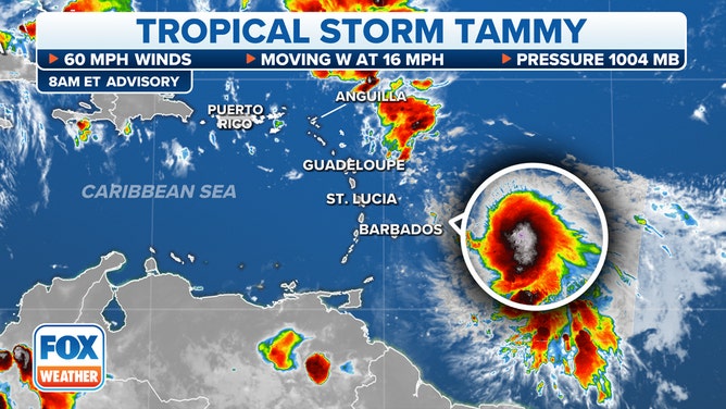
Tropical Storm Tammy is expected to gradually strengthen as it approaches the Leeward Islands and tropical storm conditions are expected to arrive in the region starting Friday.
(FOX Weather)
The atmospheric environment east of the islands is only moderately conducive for strengthening, so the system is not expected to suddenly intensify into an intense hurricane. But Tammy is expected to be near or just over hurricane strength when it’s in the vicinity of the islands.
The various computer models have finally come into reasonable agreement on Tammy’s track. About the time the center of the storm gets close to Barbados, the consensus of the various forecasts is that Tammy will turn north, tracking over or near Guadeloupe and the islands to the north tomorrow and Saturday. It should be pulling away from the Caribbean on Sunday and arc north into the open Atlantic.
Heavy rain and very gusty winds in exposed areas are expected on the impacted islands. The National Hurricane Center is forecasting 3 to 6 inches of rain from Tammy with some areas receiving 10 inches. On Puerto Rico and the Virgin Islands, some heavy rain is expected as well, but it currently appears that those islands will be on the fringe of the storm.
Just because the various computer forecasts have come into general agreement about Tammy’s track doesn’t mean they’re not all wrong. A shift that could bring greater impacts to more islands is still possible. As with all developing systems, forecasts are still prone to larger errors than for well-organized systems.
On the islands with watches, it’s time to prepare. Warnings will be issued soon. Elsewhere in the northeast Caribbean, stay informed and listen for local alerts.
Otherwise, nothing appears in the offing in the next week, at least.