Bryan Norcross: Tammy reaches hurricane strength near islands Saturday
The ocean water under Tammy is plenty warm, but upper-level winds over the system are making the atmospheric environment slightly hostile to development, which has been slowing the intensification process

FOX Weather is your Hurricane HQ, streaming free 24/7.
(FOX Forecast Center)
Updated Friday at 9 a.m. ET
Hurricane Tammy is gaining some organization, which is a key step toward a storm intensifying.
The ocean water under Tammy is plenty warm, but upper-level winds over the system are making the atmospheric environment slightly hostile to development, which has been slowing the intensification process. Computer forecasts show a somewhat more conducive environment later today into tomorrow, however, so the National Hurricane Center is forecasting Tammy to reemain at hurricane strength.
Tropical Storm Tammy is gaining some organization, which is a key step toward a storm intensifying.
(NOAA)
There is a strong consensus among the various computer forecasts that the center of Tammy will track over or just east of the northeastern Caribbean islands over the next two days and slowly pull away to the north by late Saturday. The National Hurricane Center’s forecast cone is normally centered on that consensus – essentially an average of the best computer models – and this is no exception.
The odds favor the strongest winds with Tammy staying offshore, east of the island. But that’s not 100%. A little wobble to the left could bring hurricane-force winds over the islands, so Hurricane Watches are in effect. In any case, very gusty winds and flooding downpours on some of the islands appear likely. Up to 12 inches of rain are forecast over the Leeward Islands from Guadeloupe to Anguilla.
The storm is not very large in diameter, but its forward progress will be slow, which accounts for the possibility of very heavy rain on the impacted islands. Puerto Rico and the Virgin Islands will be well west of Tammy’s track, but a combination of outer bands from the storm and an upper-level low-pressure system will keep the possibility of squally weather with gusty winds in the forecast at least through tomorrow.
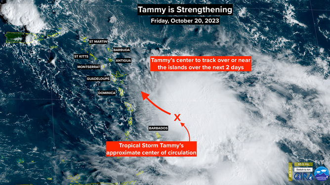
There is a strong consensus among the various computer forecasts that the center of Tammy will track over or just east of the northeastern Caribbean islands over the next two days and slowly pull away to the north by late Saturday.
(NOAA)
Everyone in the northeast Caribbean should stay in close touch with the latest local forecasts and information.
After the center of Hurricane Tammy passes the islands late tomorrow, there’s a big question about how fast it will move away to the north. The dip in the jet stream that’s scooping it up looks likely to move by, so Hurricane Tammy’s progress into the open Atlantic is expected to be slow. That will be something to keep an eye on early next week.
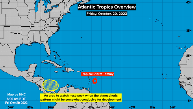
In the extreme southern Gulf of Mexico, the National Hurricane Center is painting an area where there’s a slight chance of development next week. Some long-range forecasts show a short window of time when the environmental pattern could be conducive for a system to spin up. There is nothing to see now, but it’s a place to watch.