Bryan Norcross: Tropical Storm Sean forms in eastern Atlantic, joined by new disturbance 94L
A new fairly robust Tropical Disturbance – officially tagged Invest 94L – has moved off Africa. Unlike Sean, this system isn’t forecast to turn north right away, so we’ll have to watch it as it slowly proceeds to the west over the next several days.

FOX Weather is your Hurricane HQ, streaming free 24/7.
(FOX Weather)
Updated Wednesday at 9 a.m. ET
The Gulf system we’ve been following has morphed into a non-tropical coastal storm on schedule. The combination of the ex-disturbance, a front, and tropical moisture from ex-Hurricane Lidia will produce widespread rain along the Gulf coast from Texas to Florida.
Many of the affected areas have been in extreme or exceptional drought, so this rain will be reason for celebration.
Late today, however, the low-pressure system combined with strong high pressure to the north will produce windy conditions along with heavy rain across the Louisiana and Mississippi coast. Winds gusting to over 40 mph on land and over 50 mph over the water are forecast.
Gulf water will be pressed against vulnerable coastlines. Stay aware of local alerts for flooding due to heavy rain and to Gulf-water rise, especially around high tide.
The system will spread east bringing very heavy rain to North Florida and south Georgia later today into tomorrow before it heads into the Atlantic.
An overview of the Atlantic Basin.
(FOX Weather)
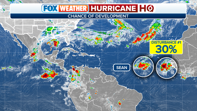
In the eastern Atlantic, Tropical Storm Sean has formed – the 19th named storm of the season. The environment ahead of Sean if marginal at best, so the National Hurricane Center is predicting only slight strengthening. Steering currents are weak, so Sean isn’t expected to get very far west before it dies out without affecting land.
A new fairly robust Tropical Disturbance – officially tagged Invest 94L – has moved off Africa. Again, the steering currents are weak, so this system is forecast to stroll across the tropical Atlantic as it heads in the general direction of the Caribbean. The atmospheric pattern ahead appears marginally conducive for development over the next week.
Unlike Sean, this system isn’t forecast to turn north right away, so we’ll have to watch it as it slowly proceeds to the west over the next several days.