Tropical Storm Lisa is likely to intensify today in the Caribbean
Thunderstorms have had difficulty organizing around Lisa’s center of circulation due to slightly hostile upper winds and dry air disrupting the circulation. The atmospheric environment is forecast to become more conducive for Lisa to organize and strengthen today, however.
The podcast Tracking the Tropics with Bryan Norcross is now available to stream.
(FOX Weather)
Updated at 8:15 a.m. Eastern
Tropical Storm Lisa has been slow to pull itself together, but that process is forecast to accelerate today as the system heads in the general direction of Belize. On the satellite, the storm already has the look of a more organized system. On the current schedule, Lisa will make landfall tomorrow.
Thunderstorms have had difficulty organizing around Lisa’s center of circulation due to slightly hostile upper winds and dry air disrupting the circulation. The atmospheric environment is forecast to become more conducive for Lisa to organize and strengthen today, however. With lighter upper-level winds pushing less dry air into the system, the computer forecast models and the National Hurricane Center forecast Lisa to strengthen.
HOW TO WATCH FOX WEATHER ON TV
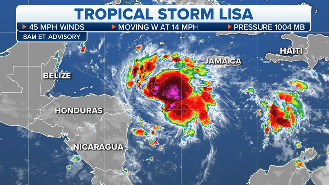
The latest on Tropical Storm Lisa.
(FOX Weather)
The official NHC forecast is for Lisa to reach hurricane strength before it reaches the Belize or Mexican coast tomorrow afternoon, plus or minus. Forecasts of intensity are always iffy in a changing atmospheric environment, however. It’s easy to imagine the system spiking in intensity higher than forecast, and it’s also reasonable to think that the dry air over the western Caribbean will continue to gum up the works and slow the process, at least to some degree.
The course of least regret is for people in Belize and the southern half of the Yucatán Peninsula of Mexico to be ready for a Category 2 hurricane. The northern coast and especially the Bay Islands of Honduras are also on alert.
The landfall location is critical because the areas to the north will be impacted by storm surge predicted to run 3 to 5 feet above the normal tide level. With Lisa just now developing, the exact landfall point is still an open question.
High pressure over the Gulf of Mexico and Florida will confine Lisa to the Caribbean. After landfall in or near Belize tomorrow, Lisa will likely die out quickly over Central America. Flash flooding will be a threat at least through Thursday in Belize and the surrounding areas.
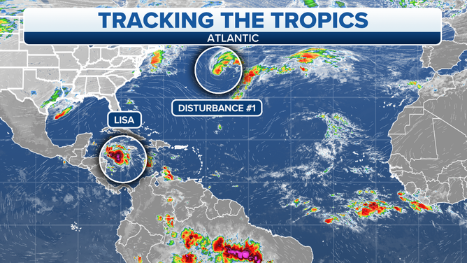
The Atlantic tropical overview.
(FOX Weather)
In the central Atlantic east of Bermuda, Disturbance #1 is a non-tropical low-pressure system with a short window of time to become a tropical or subtropical system. Subtropical systems have characteristics of both tropical and northern-latitude storms. It’s tracking over decently warm water, which gives it a chance to evolve into a tropical or subtropical (hybrid) storm. Whatever happens, it won’t threaten land.
The National Hurricane Center is giving the system a high chance of becoming Tropical Storm or Subtropical Storm Martin today or tomorrow. After that, it will move into the cold North Atlantic.
Looking ahead, the long-range computer forecast models show some sort of low-pressure system forming over or near the Bahamas early next week. The weather pattern is forecast to be hostile to tropical development, but it’s possible that a hybrid or non-tropical system could form.
It’s something to keep an eye on, but not a significant concern at this point.
FOX Weather Hurricane Specialist Bryan Norcross has a podcast, Tracking the Tropics with Bryan Norcross, available now on FOX News Audio. You can get it on your device by clicking here.