Tropical Storm Ian's future track continues to be highly and unusually uncertain
The National Hurricane Center is predicting that Ian will be a powerful, perhaps Category 3, hurricane when it approaches western Cuba late tomorrow.
The podcast Tracking the Tropics with Bryan Norcross is now available to stream.
(FOX Weather)
Updated at 8:15 a.m. Eastern
Tropical Storm Ian is still getting organized in the Caribbean Sea south of Jamaica. There is now no obvious external factor limiting it, so the expectation is the organization process will conclude today, and a rapid intensification process will begin by tonight.
The National Hurricane Center is predicting that Ian will be a powerful, perhaps Category 3, hurricane when it approaches western Cuba late tomorrow.
There is general agreement among the various computer forecast models on this portion of the track. There is a slight amount of east-west spread from over Cuba to just off the island's west end, but this is normal.
By Wednesday, however, the differences in the forecast models are profound. Essentially, some models take the storm down the left side of the cone well offshore of the Florida coast in the Gulf of Mexico and into the Panhandle. Other models drive the hurricane down the right side of the cone and curve it into the Florida west coast.
As different as they are, both tracks are credible.
HOW TO WATCH FOX WEATHER ON TV
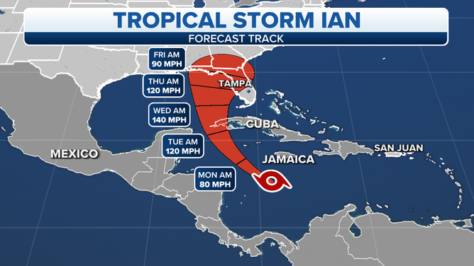
A map showing the latest forecast track for Tropical Storm Ian.
(FOX Weather)
Ian is forecast to be a Category 4 monster as it's entering the Gulf. As it continues north, there is good agreement among the longer-range forecasts that the upper-level environment will become more hostile, and Ian will weaken. The unresolved question is whether the system hangs a right and comes ashore as a powerful storm before the environmental regime changes. Does the weakening occur over the ocean or over the Florida peninsula? That's unknown.
And this is very important, if the storm weakens over the Gulf, it will grow in size and still produce life-threatening storm surge on the Florida Gulf coast. The physically larger the storm, the higher it will push the Gulf water over the land. In addition, Ian's forward speed is forecast to slow significantly, which would also produce higher storm surge.
The threat is NOT over for Tampa Bay or anywhere else from Southwest Florida to the Panhandle. Spread that word.
The National Hurricane Center's forecast cone is a compromise between these unusually divergent tracks. This implies that the uncertainty in the current forecast is extremely high. Until that uncertainty is resolved, everybody has to stay vigilant and pay attention to their local officials, who are tasked with keeping everybody safe.
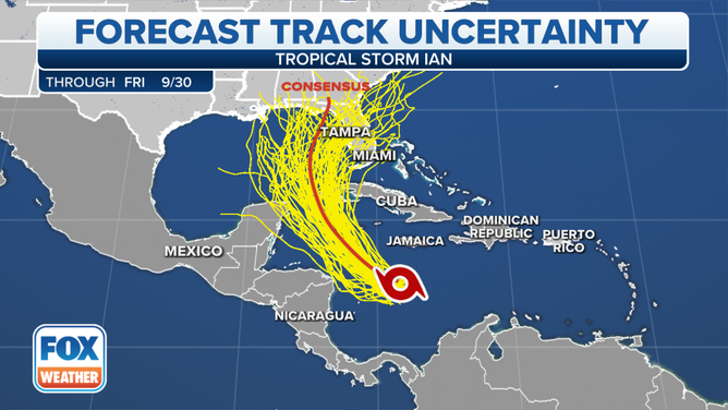
The possible path of Tropical Storm Ian.
(FOX Weather)
NOAA and the National Weather Service are using every tool available to provide more clarity, and they will continue to pull out all the stops for the next several days. Normally, their best technique is to gather extra atmospheric data around the storm and across the U.S. to be sure the computer forecast models are fed as much detailed information as possible. Often, the extra data brings the various models into closer agreement. But that has not yet happened.
Even if the forecasts come into better alignment, they will never be perfect. A Category 3 or 4 storm in the Gulf is and extremely dangerous scenario. No matter what, it will be felt in some fashion from the Keys to the Panhandle. It's critical that everyone stay informed. As we have seen, the forecasts can suddenly change.
The other systems in the Atlantic are of no consequence, and nothing else appears in the offing this week.