Tropical Storm Fiona to bring heavy rains to Puerto Rico, nearby islands; future track fuzzy
The system is heading toward the northeastern Caribbean islands, including Puerto Rico and the Virgin Islands. The storm is pushing against dry air and somewhat hostile upper winds, which should keep it from suddenly intensifying, if it intensifies much at all.
The podcast Tracking the Tropics with Bryan Norcross is now available to stream.
(FOX Weather)
Updated at 8:45 a.m. Eastern
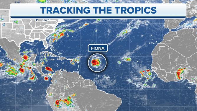
Tropical Storm Fiona somewhat surprisingly formed last evening from the disturbance we followed across the tropical Atlantic. The system is heading toward the northeastern Caribbean islands, including Puerto Rico and the Virgin Islands. The storm is pushing against dry air and somewhat hostile upper winds, which should keep it from suddenly intensifying, if it intensifies much at all. Although we were surprised it organized so quickly in the first place.
Fiona is only half a storm due to the dry air and upper winds pushing the bad weather to the back half of the storm's circulation. This adds to the idea that it will only slowly strengthen, if it does. The official forecast from the National Hurricane Center maintains Fiona as a mid-strength tropical storm until it reaches the islands.
Beginning late tomorrow, confidence is high that the system will steadily move through the northeastern Caribbean islands, the Virgin Islands, and be near Puerto Rico on Saturday. Gusty winds will impact the islands, although the biggest concern will be the extended period of heavy rain falling on already saturated soil – 3 to 6 inches of rain are forecast.
Tracking Tropical Storm Fiona.
(FOX Weather)
This part of the forecast appears straightforward. It's what happens afterward that's murky. The various computer forecast models are all over the place. Some move it slowly and some more quickly through the islands. And the speed affects what happens next.
A dip in the jet stream is forecast to move over Florida and the Bahamas early in the week. It should provide an opening for Fiona to turn north. Although, if the system is too weak at that time, there's a chance Fiona could duck under the scoop and continue west toward Cuba.
But most computer forecast solutions turn the system north before it gets to the Bahamas, but they differ on where Fiona will be located and how strong it will be when it makes the turn. Since the future track and the intensity are interlinked, and the intensity is highly iffy due to the marginal environment and the possibility it will interact with the Dominican mountains, we have to assume the forecasts will jump around.
If the storm avoids being disrupted by the mountains and stays relatively strong, it's more likely to turn north early, perhaps around Puerto Rico. If it's weaker, the computer forecasts indicate it will turn later and could affect the Bahamas.
HOW TO WATCH FOX WEATHER ON TV
Assuming it makes the turn and is in the Atlantic north of the islands early to midweek, we should have a better idea of its future track without the uncertainty of the mountains and other factors involved. How close or far from the U.S. coast it would track is very dependent on where and when Fiona turns north because the jet-stream scoop will evolve in shape and strength with time, so the path north will evolve as well.
We also can't completely rule out the idea that Fiona misses the scoop and continues toward Cuba, but this appears to be an outlier possibility at this time.
Elsewhere, there is a disturbance that just moved off Africa, but there are no signs of development for now.
FOX Weather Hurricane Specialist Bryan Norcross has a podcast, Tracking the Tropics with Bryan Norcross, available now on FOX News Audio. You can get it on your device by clicking here.