Tropical Storm Earl to linger near Puerto Rico, nearby islands through weekend
Because the system has a well-defined circulation and persistent thunderstorms with winds measured at 40 mph, it meets the definition of a tropical storm. As long as it maintains this off-kilter structure with dry air involved in the circulation, only slow intensification is forecast, if it intensifies at all.
The podcast Tracking the Tropics with Bryan Norcross is now available to stream.
(FOX Weather)
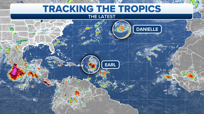
Updated at 9 a.m. Eastern: The disturbance we’ve been tracking across the Atlantic has finally acquired enough of a circulation to be designated Tropical Storm Earl – although it’s a very disorganized tropical storm. Upper-level winds are pushing the thunderstorms away from the center, which is clearly exposed on the satellite.
Because the system has a well-defined circulation and persistent thunderstorms with winds measured at 40 mph, it meets the definition of a tropical storm. As long as it maintains this off-kilter structure with dry air involved in the circulation, only slow intensification is forecast, if it intensifies at all.
HOW TO WATCH FOX WEATHER ON TV
The steering currents are forecast to significantly weaken over the next couple days, so Earl is expected to linger over the ocean waters north of Puerto Rico, the Virgin Islands, and the islands nearby through the weekend, at least.
An overview of the Atlantic Ocean.
(FOX Weather)
In a couple days, a dip in the jet stream is forecast to move off the Northeast coast of the U.S. This system should be strong enough to scoop up Earl and pull it north away from the islands by late Monday or Tuesday.
This should all work, as long as Earl stays strong enough to be grabbed by the jet-stream dip. If it should weaken over the next couple days, its movement would be slower and less predictable.
With Earl nearby, its moisture envelope including its moisture tail will linger over the northeastern Caribbean islands. Some heavy tropical downpours can be expected that could cause mudslides in vulnerable areas, especially on the mountainous islands. Pay attention to local advisories.
In the North Atlantic, Danielle weakened slightly and is now down to tropical-storm strength. It’s been sitting in essentially the same spot for a while, so it’s possible that it churned up some cold water from under the surface of the ocean.
HOW TO DOWNLOAD THE FOX WEATHER APP
In the next few days, the blocking high-pressure system that has been holding Danielle in place is forecast to shift its position so the storm can exit to the northeast. It will eventually be absorbed into another weather system moving across the far North Atlantic.
Looking ahead at the tropical Atlantic, the long-range computer forecast models indicate that more disturbances will move off Africa next week and beyond, as we’d expect this time of year. But none appear to be a threat for the foreseeable future.
FOX Weather Hurricane Specialist Bryan Norcross has a podcast, Tracking the Tropics with Bryan Norcross, available now on FOX News Audio. You can get it on your device by clicking here.