Bryan Norcross: Tropical Storm Bret stronger as it heads toward the Caribbean
The most reliable hurricane forecast models are in solid agreement, which gives us confidence in the National Hurricane Center forecast.
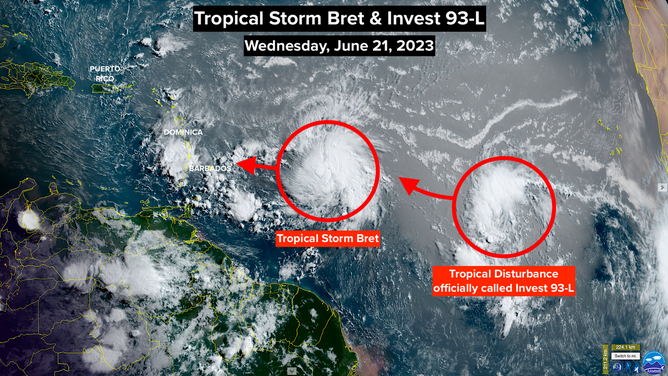
A satellite view of the tropical Atlantic of Tropical Storm Bret and Invest 93L
(NOAA)
Tropical Storm Watches are in effect for the east-central Caribbean islands as Tropical Storm Bret barrels toward them.
On the current schedule, Bret will pass through the islands tomorrow evening and overnight. The biggest threats will be flooding rain and very gusty winds, especially on the sides of the mountain exposed to the east and northeast wind.
The most reliable hurricane forecast models are in solid agreement, which gives us confidence in the National Hurricane Center forecast. The highest chance of strong winds is from Barbados to Dominica, including Martinique and St. Lucia. Though there could be gusty squalls outside that zone.
Residents should not focus on the forecast track for Bret’s center, that is, the center line of the cone. The strongest winds will be in a band on the north side. Fewer effects will likely be felt south of the center.
All forecasts show the atmospheric environment becoming more hostile as Bret reaches the Caribbean, so a weakening process will likely begin. It’s still too close to call whether that will begin before the center crosses the islands. In any case, strong winds, some gusting to hurricane strength, should be expected on the affected islands.
Once Bret enters the Caribbean, the atmospheric environment will become increasingly hostile. It appears likely that Bret will dissipate in the waters south of the Dominican Republic and Haiti about Saturday.
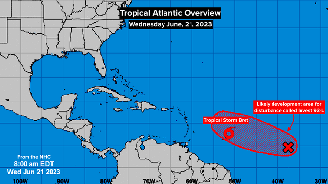
Tropical Atlantic overview of Tropical Storm Bret and Invest 93L
(NOAA)
Very little effect on the island of Puerto Rico and on the Virgin Islands is expected with Bret passing well to the south. Seas and surf will be dangerous, however.
Behind Bret is a tropical disturbance officially called Invest 93L by the National Hurricane Center. The disturbance is just beginning to show signs of development. The atmospheric pattern ahead of the system looks sufficiently conducive for it to develop into a tropical depression. Some computer forecasts show it getting strong enough to become Tropical Storm Cindy.
This system is not a threat to land, however. All the forecasts show it turning north into the open ocean.
Another disturbance will move off Africa late tomorrow or early Friday. By that time, more dry air is forecast to cover the tropical Atlantic, which is typical for this time of year. So there’s a decent chance that that next system will have more trouble developing.
It’s not at all normal, of course, to have tropical systems developing in this part of the ocean in June. Bret developed farther east in the tropical Atlantic than any June storm on record. It’s not clear whether this is a harbinger of more hurricanes this season or not. But it is concerning nonetheless.