Bryan Norcross: Tropical Storm Bret forecast to impact Caribbean islands near hurricane strength
On average, the third named storm comes in August, as does the first hurricane. So we are in very unusual territory with this June development.

Tropical Storm Bret, Invest 93L continue strengthening in the Atlantic
Tropical Storm Bret is expected to develop into a hurricane as early as Wednesday and Invest 93L could develop into a tropical depression or Tropical Storm Cindy after that. FOX Weather hurricane specialist Bryan Norcross breaks down why we're seeing an active start to the 2023 Atlantic hurricane season.
Highly unusual Tropical Storm Bret looks reasonably impressive on the satellite as it plows west through an unusually warm tropical Atlantic. The National Hurricane Center is forecasting the intensification process to continue for another day and a half or so as the storm heads toward the eastern Caribbean islands. About that time, the atmospheric environment starts becoming more hostile.
On the current schedule, the weather will start deteriorating in the Caribbean islands on Thursday, with the strongest winds passing through sometime late at night. The worst weather will be to the north of the center, with few effects to the south.
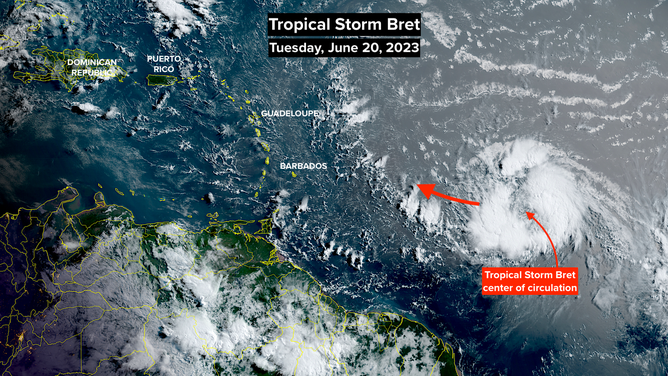
A satellite image of Tropical Storm Bret.
The current forecast from the National Hurricane Center predicts Bret will reach Category 1 hurricane intensity well before it reaches the islands and will slowly weaken as it moves into the northeastern Caribbean Sea. The exact point when the somewhat more hostile atmospheric environment causes the storm to weaken, and how fast that takes place, is an open question.
The consensus of the best computer forecast models says that Bret will have a band of hurricane-force winds north of its center when the center nears the central Caribbean islands. If the storm stays stronger longer, it will likely track farther north.
A combination of hostile upper winds and dry air should start to impact Bret about the time it enters the Caribbean. It's too close to call at this time whether the unsupportive environment will start a weakening process before or after the center of the storm crosses the islands, but significant weakening appears likely by the end of the week when the storm is in the Caribbean.
The effects on Puerto Rico and the Virgin Islands are too far in the future to predict. What's left of Bret's band of strongest winds could impact the islands directly, or they could miss well to the south. Everyone in the central and northeastern Caribbean islands needs to stay well-informed this week.

The NHC tropical Atlantic overview.
The hostile atmospheric pattern over the central Caribbean, the Bahamas and Florida should disrupt the circulation, so all that's left is a moisture surge. There's no apparent threat to the U.S. or the surrounding areas.
To the east of Bret is a tropical disturbance that the National Hurricane Center has labeled Invest 93L. This disturbance also has a conducive atmosphere ahead of it, so it's likely to develop into at least a tropical depression. In fact, the consensus of the best computer models is that it will become Tropical Storm Cindy in a few days.
At this point, the odds highly favor potential Cindy turning north before reaching the islands.
There is no question that the extremely warm waters in the tropical Atlantic are contributing to this rare early outbreak of activity. But this situation is different from years in the past when the ocean-water temperatures have been warmer than average. This year, the oceanic heat wave extends north all the way to Great Britain in the eastern Atlantic. Logically, this exceptional warm-water pattern is affecting the atmospheric pattern as well, which could be contributing to the unusually conducive environment.
Officially we count the unnamed subtropical storm in January as a named storm, so Bret is No. 3 for the season. On average, the third named storm comes in August, as does the first hurricane. So we are in very unusual territory with this June development.
We talked a lot about a developing El Niño in the Pacific this year, which generally limits storm development in the Atlantic. That process is still building and hasn't kicked in yet. So there is still hope that it will help control things later in the season.
In any case, this year's extreme heat in the oceans is not something we've seen before, so predicting too far ahead is a bad idea.