Bryan Norcross: Tropical Disturbance in the far eastern Atlantic has a medium chance of developing
The National Hurricane Center is giving the system a medium chance of developing into at least a tropical depression over the next several days.

FOX Weather is your Hurricane HQ, streaming free 24/7.
(FOX Weather)
UPDATED Thursday at 8:30 a.m.
The extremely defuse Tropical Disturbance that moved off the African coast at the beginning of the week has a chance of developing in a few days. For now, it’s embedded in a dense plume of Saharan dust, which is keeping thunderstorms to a minimum. There are so few clouds and showers with the system that it’s hard to pick out where the center is currently located.
Over the weekend or early next week, the consensus of the various computer forecasts is that the system will break free of the densest part of the dust plume and gather enough moisture to develop into at least a tropical depression.
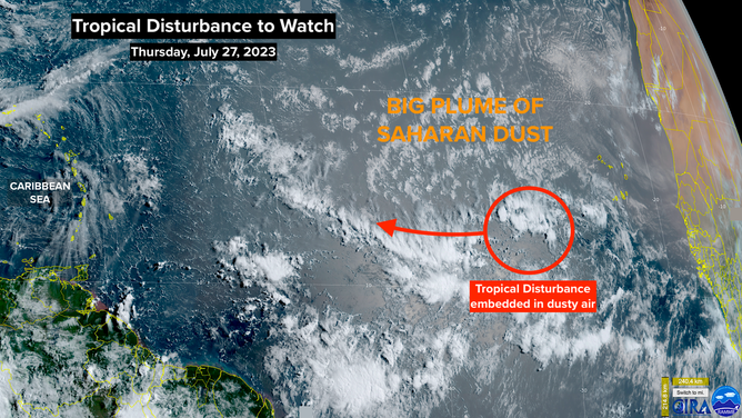
NOAA satellite image of a tropical disturbance in the Atlantic and Saharan dust.
(NOAA)
A blocking high-pressure system to the north is currently propelling the disturbance on a westerly path, but a break in the high should allow a northward turn over the weekend.
The National Hurricane Center is giving the system a medium chance of developing into at least a tropical depression over the next several days.
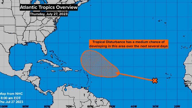
Tropical disturbance in the Atlantic.
(NHC)
Notice that the potential-development zone is a broad area northeast of the Caribbean. The disturbance will most likely be somewhere in that zone late in the weekend or early next week. At that time, the atmospheric conditions are forecast to be moderately conducive for development.
There is a strong consensus in the computer model forecasts that a strong dip in the jet stream will move off the East Coast of the U.S. early next week. If that happens, the system will turn to the north well away from land. But it’s too early to be sure. If the disturbance does not develop, it could track farther west than the current forecasts indicate.
As of now, there is no threat to land from this system and no other threats pending.