Tropical development in the Caribbean looks increasingly likely
Since the system doesn't yet exist, and it's forecast to form from a combination of other weather systems, we're designating it Potential Tropical Disturbance #2.
The podcast Tracking the Tropics with Bryan Norcross is now available to stream.
(FOX Weather)
Updated at 9 a.m. Eastern:
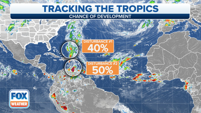
The consensus of the computer forecast models is that an organized tropical system will form in the eastern Caribbean Sea over the weekend. Since the system doesn't yet exist, and it's forecast to form from a combination of other weather systems, we're designating it Potential Tropical Disturbance #2.
The National Hurricane Center gives the system a medium chance of developing somewhere in the eastern part of the Caribbean between late Saturday and Tuesday.
The bad weather currently affecting Puerto Rico and the Virgin Islands is only a piece of the puzzle that appears likely to come together in one fashion or the other in a few days. Currently, an unusually sharp dip in the jet stream is scooping moisture from a weak tropical disturbance and drenching Puerto Rico and the surrounding islands. This particularly wet weather pattern will slowly wane, but more moisture is coming next week.
HOW TO WATCH FOX WEATHER ON TV
Areas to watch in the Atlantic Ocean for potential tropical development.
(FOX Weather)
Another surge of moisture associated with yet another weak tropical disturbance is scheduled to arrive in the Caribbean late Friday or Saturday. If the dip in the jet stream with its strong upper winds were still in place at that time, nothing could develop because the dip creates an environment that is hostile to tropical systems. But the dip is forecast to pull north and leave a weather pattern that is very conducive to tropical development.
Assuming things play out as predicted, the new Atlantic disturbance, along with the suddenly supportive atmospheric environment, will allow a tropical depression or tropical storm to spin up over the southern Caribbean north of Venezuela. This system is not expected to directly affect Puerto Rico and the surrounding islands, but some of its peripheral moisture may kick off another rainy period early in the week.
A blocking high-pressure system is forecast to build across the Gulf of Mexico, Florida, and the adjacent Atlantic next week. The long-range computer forecast models show the block holding the developing system in the Caribbean. At the same time, the flow around the high will push the system to the west in the direction of Central America. Jamaica will have to watch how and where the system develops as well.
The consensus is very strong that high pressure will confine the system to the Caribbean, assuming it develops. But it's too soon to know how strong the storm might become or where it might impact land next week.
To the north, Disturbance #1 is on the way to developing into a hybrid low-pressure system. It is expected to have characteristics of both a wintertime and a tropical system. Systems like this are called subtropical depressions or storms.
In any case, the disturbance is forecast to drift around between Bermuda and the Southeast U.S. for a day or two before being swept into the North Atlantic.
The change in seasons has pushed cold fronts through the Gulf of Mexico cooling the water and making the weather pattern inhospitable to tropical systems. So no threats to the U.S. are likely in the foreseeable future.
FOX Weather Hurricane Specialist Bryan Norcross has a podcast, Tracking the Tropics with Bryan Norcross, available now on FOX News Audio. You can get it on your device by clicking here.