Bryan Norcross: Major hurricane threat to the Florida Gulf coast including around Tampa Bay begins tomorrow
The Florida Gulf coast is extremely vulnerable to deadly storm surge – the Gulf and Bay water being pushed up over the shorelines and beaches and into neighborhoods. It is critical to pay attention to local emergency information.
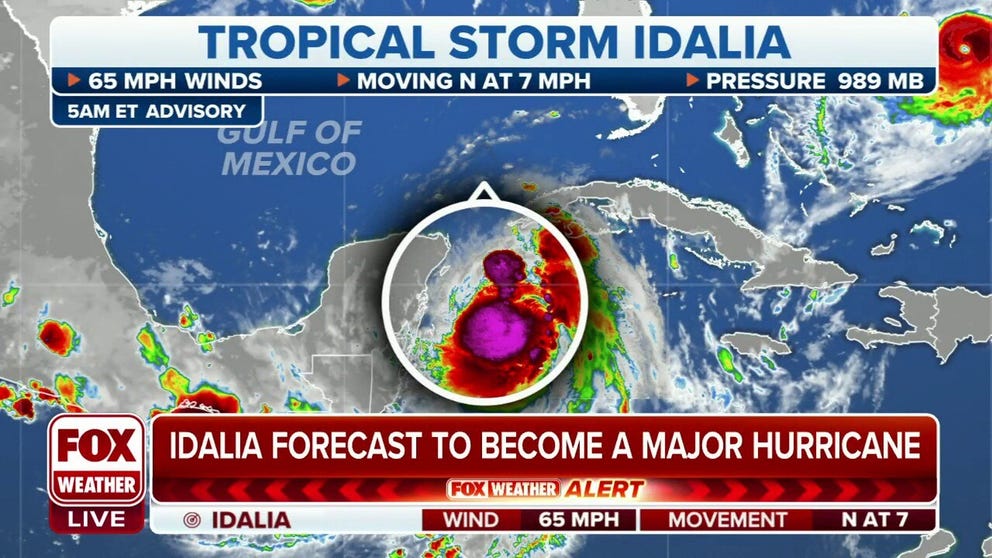
Tropical Storm Idalia expected to strengthen into major hurricane before Florida landfall
Florida residents living along the Gulf Coast are being urged to prepare for Tropical Storm Idalia, which is expected to strengthen into a major hurricane before making landfall this week.
Updated on Monday at 7:45 AM
Tropical Storm Idalia is slowly starting its move to the north from the northeastern Caribbean. Here's what we know:
- Rainy, gusty weather will overspread a good part of the Florida peninsula beginning tomorrow. The dip in the jet stream that will help propel Idalia north will also pull moisture out of the system and spread it north.
- The rain may pause but then return in increasingly strong bands. Some rain will be very heavy. Despite the drought conditions, flooding of low-lying areas is a possibility. The forecast is for 4 to 8 inches, with some locations in the storm's path receiving a foot of rain.
- The peak wind and storm surge will likely reach the Florida coast in the AM hours of Wednesday, possibly before sunrise. It depends on how far south the system makes landfall.
- The Florida Gulf coast is EXTREMELY vulnerable to deadly storm surge – the Gulf and Bay water being pushed up over the shorelines and beaches and into neighborhoods. It is critical that everybody pays attention to local emergency information.
Understandably, everybody wants the best forecast information. I am constantly asked, "What computer model do you look at?" The answer is easy: I look at the National Hurricane Center forecast. It is consistently the most consistent and accurate public information.
I also look at the various models to understand the uncertainty intrinsic in the weather pattern on a given day. If the European model goes one way and the American GFS model goes another, the Fox Model goes slow, and the HAFS goes fast, I know there is relatively high uncertainty. If they all basically go the same place, we can have more confidence.
Sometimes every computer forecast is wrong in the same direction, but that is rare and most often happens when the tropical system is drifting and/or just organizing.
That's clearly the situation with Idalia, so the forecasts have had a bit more uncertainty attached to them. But now that the storm is getting organized and starting to move, we expect more consistent forecasts.
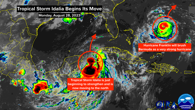
Tropical Storm Idalia and Hurricane Franklin in the Atlantic basin
(NOAA / FOX Weather)
The most important information issued by the National Hurricane Center is the specific forecast information in the bulletin with the Storm Surge Watches and Warnings. It is critical that everyone from the Florida Big Bend south on the Gulf coast, including around and near Tampa Bay, know what's forecast for their location and what the instructions are from the local emergency management office.
As of this writing Monday morning, the storm surge forecast for Tampa Bay is 4 to 7 feet. This means the National Hurricane Center is forecasting the water in and around Tampa Bay to rise UP TO 7 FEET ABOVE NORMAL HIGH TIDE. If that happens, MANY neighborhoods around the bays and rivers and near the beaches will be covered.
They are not predicting that's what is going to happen. They are saying that water 7 feet above normal high tide COULD cover the land in the warned areas based on everything we know. We have to be ready for that possibility.
As we saw last year with Hurricane Ian, the storm surge predictions can and often do change as the storm gets closer and the forecast becomes more certain. But don't wait. Don't get stranded because your exit routes are clogged.
You are endangering the lives of your family and friends if you don't follow evacuation orders. Drop everything and prepare immediately if you think you're affected. Seek out the official information.
If you are wondering how windy it could be at your location, seek out the rainbow-colored map below from the National Hurricane Center. It's a probability map, which can be pretty confusing. But to boil it down, if you live in a place covered by a color, you have a chance of getting winds of 40 mph or higher, which can knock down trees, knock out power, etc. The closer you are to the center of the map, the higher your odds. There is also a version of this map that shows you the odds of hurricane-force (75+ mph) wind at each location, but the 40 mph map is a good guide to the windy areas.
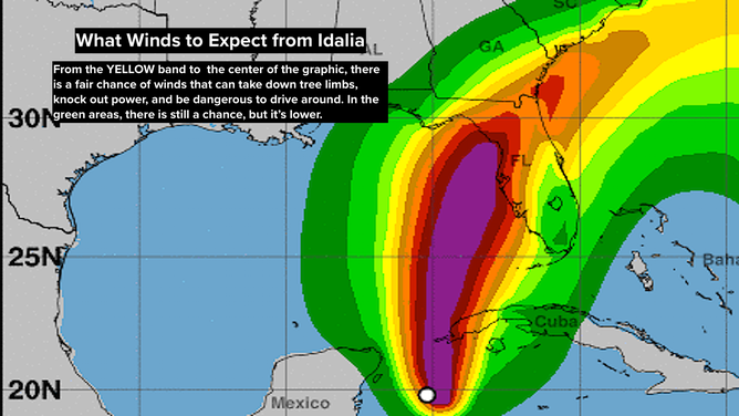
What winds to expect from Idalia
(National Hurricane Center (NHC) / FOX Weather)
The thing to remember is that the odds for your location will increase as the storm gets closer because there is more certainty in the forecast. It's not necessarily an indication that the forecast is changing.
Also, this map takes into account the spread in the computer models, so it will be wider if the computer forecasts are all over the place. But have confidence that you are getting the best information available when you look at this map – even though you and everybody else want to know exactly what's going to happen.
How strong will Idalia be when it makes landfall? That is only knowable within a wide range of possibilities between a Category 2 and something like a Category 4 at the current time. The explicit forecast from the National Hurricane Center is a Category 3. This is a case where it is necessary to prepare for the worst and hope that something better happens.
There are conflicting signals in the atmosphere. The jet stream scoop that is going to lift Idalia north can make the environment over the system more conducive for strengthening. If it shifts just over the storm, however, it can tilt the circulation over, limiting its intensification potential. Currently, the stronger scenario seems most likely.
The extremely warm Gulf water at depth is obviously a factor that will provide extra energy to the system.
Hurricane Idalia will be moving at a good clip, so the peak impacts shouldn't last very long – relatively speaking. But it also won't weaken quickly as it moves over North Florida. Winds capable of knocking out power will affect a good swath of the northern third of the state. Be ready with batteries and hurricane supplies.
Once the storm gets to Georgia and the Carolinas, it will interact with a cold front, likely enhancing the rainfall potential. Be aware of the potential for flash flooding if the ingredients come together. Storm surge flooding at the coast might also be a problem. Stay in touch with local forecasts.
This situation requires everybody's attention in the storm's path. Remember the lesson from Ian: the cone is NOT the forecast. The specific forecasts are in the Hurricane and Storm Surge Watch and Warning statements from the National Hurricane Center.
Stay informed. Be aware. Take action.