Bryan Norcross: The tropics stay calm for now while Don drifts and Calvin heads to Hawaii
In the Pacific, Hurricane Calvin is weakening but is still on track to impact the Big Island of Hawaii in a couple of days as a much-diminished storm. The current thinking by the National Hurricane Center is that the top sustained winds in the circulation will be in the 40-mph range.

Generic Hurricane HQ
(FOX Weather)
Updated Sunday 8:30 a.m. EDT
Don is barely hanging on as a subtropical storm – a hybrid between a tropical storm and a nor’easter, but worthy of a name – in the central Atlantic. It has a healthy circulation, but only a few thunderstorms are rotating around the center. It’s over chilly water for now, but if it hangs together, it might regenerate late in the week when it drifts over warmer water.
Don is trapped between high-pressure systems, so it can’t move much one way or the other. In any case, it’s well away from land and not a threat.
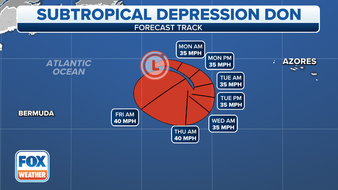
The forecast cone for Don in the central Atlantic.
(FOX Weather)
In the Pacific, Hurricane Calvin is weakening but is still on track to impact the Big Island of Hawaii in a couple of days as a much-diminished storm. The current thinking by the National Hurricane Center is that the top sustained winds in the circulation will be in the 40-mph range.
Remember, however, the wind-speed rating of a tropical system is the estimate of the wind at the surface of the ocean. Gusts are always much stronger higher on a mountain impacted by the storm. Also, it’s too close to call whether the strongest remaining band of wind will pass over the Big Island or miss just offshore.
In any case, everybody in Hawaii should stay informed of the latest alerts for the potential of very gusty winds, potential flooding, and very high surf. The first official watches will likely be issued today.
Calvin is moving at a good clip, so it should be through the islands by late Wednesday.

The forecast cone for Calvin in the Eastern Pacific.
(FOX Weather)
The tropical Atlantic is covered with a massive plume of Saharan dust. Along with hostile upper winds, the dust should keep things quiet this week, at least.
The dust and the hostile weather pattern are typical for this time, but the ocean water is still very warm. We’ll watch for faster-than-normal organization and strengthening of storms once the development window opens. That normally happens by the middle of August, of course.
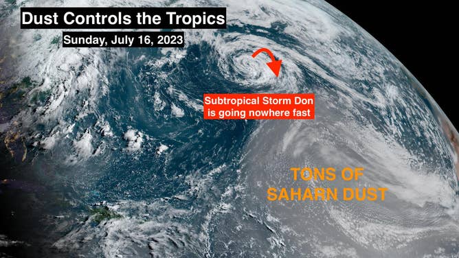
Saharan dust has overspread the tropical Atlantic.
(Bryan Norcross / FOX Weather)
The El Niño is slowly strengthening in the Pacific. And El Niño weather pattern includes somewhat hostile upper winds over the Caribbean and the western part of the tropical Atlantic. The hurricane-limiting effect of the El Niño appears likely to increase as the season goes on. But that’s just stating the odds. We’ll see.
For now, enjoy the quiet time in the tropics.