Bryan Norcross: Tammy likely to make a comeback and an area to watch in the Caribbean
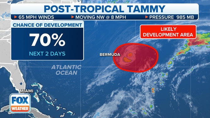
The National Hurricane Center is giving Ex-Tammy a good chance of reorganizing into a fully tropical storm pretty quickly since it still has such a robust circulation.

FOX Weather is your Hurricane HQ, streaming free 24/7.
(FOX Weather)
Updated Friday at 8:30 a.m. ET
Yesterday morning, Hurricane Tammy merged with a cold front and its associated non-tropical low-pressure system over the still-warm Atlantic well east of Bermuda. Recall that a front is the line between two air masses – typically cooler air to the north and warmer air to the south. When a weather system is connected to fronts, the contrast in air temperature provides the energy as opposed to the heat from the ocean. This is what makes the system non-tropical.
Over time, however, the temperature contrast across the front decreases as the warm ocean warms the air. That process is well underway with the fronts that are connected to ex-Tammy. By later today, it appears that the Tammy circulation will exist on its own again. This will give it an opportunity to convert back into a tropical system, which draws its energy exclusively from the ocean. It will take a bit of time because the thunderstorms have to consolidate and grow closer to the center.
Post-Tropical Cyclone Tammy is being monitored for redevelopment over the next seven days.
(FOX Weather)
The National Hurricane Center is giving Ex-Tammy a good chance of reorganizing into a fully tropical storm pretty quickly since it still has such a robust circulation.
Mostly, this is only important for the meteorological record book. Bermuda will experience the same tropical-storm-force winds blowing from the north today, whether Tropical Storm Tammy makes a technical comeback or not. In any case, the storm is forecast to drift toward the island today, but by tomorrow, the consensus of the computer forecasts is that Tammy will turn around and head out to sea.
Farther south in the Caribbean, computer forecasts are indicating that a broad area of low pressure will develop over the weekend. The National Hurricane Center is giving it a low chance of becoming at least a tropical depression next week, but it’s possible. If it were to organize and attain winds of at least 40 mph, it would become Tropical Storm Vince.
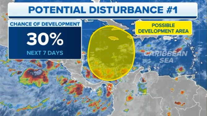
The National Hurricane Center outlined an area in the southwestern Caribbean Sea for possible tropical development.
(FOX Weather)
Unless something unexpected happens, the cold fronts pushing through Florida should shield the Southeast U.S. by keeping tropical systems to the east. However, residents in the northern Caribbean islands and the Bahamas should plan to stay informed next week on the latest forecasts.
The preliminary indications are that the atmospheric pattern won’t be especially conducive for quick development, but we’ll have to see if and exactly where a system tries to organize.
The Caribbean is where we watch this time of year because a winter weather pattern is dominating farther north.