System forecast to develop near the Bahamas to affect the U.S. East Coast next week
The development of the low is forecast to take place through the same mechanism that upper disturbances create nor’easters in the north. As a result, The National Hurricane Center is giving this potential system a low chance of becoming somewhat tropical at this point. If it does, the process will be slow.
The podcast Tracking the Tropics with Bryan Norcross is now available to stream.
(FOX Weather)
Updated at 9:15 a.m. Eastern
The computer forecast models insist that a non-tropical low-pressure system will form over the open ocean north of Puerto Rico and east of the Bahamas over the weekend. The low will be spawned by an unusual, large, circular upper-level disturbance that is forecast to drop into the area over the Bahamas and Florida and drift around into next week.
The development of the low is forecast to take place through the same mechanism that upper disturbances create nor’easters in the north. As a result, The National Hurricane Center is giving this potential system a low chance of becoming somewhat tropical at this point. If it does, the process will be slow.
HOW TO WATCH FOX WEATHER ON TV
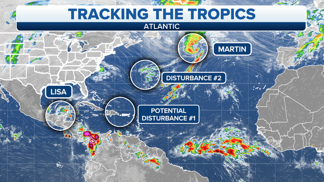
A graphic showing an overview of the tropical Atlantic Ocean.
(FOX Weather)
We’re calling this system Potential Disturbance #2 since there is no system to track on the weather map yet.
Once the low develops, assuming it does, the current expectation is for it to track around the big donut of winds surrounding the upper disturbance in an arc toward Florida or the Southeast. There is a chance that during the process of the traversing the warm ocean water, including the Gulf Stream, the low-pressure system will acquire some tropical characteristics.
There are a lot of ifs and maybes about the meteorology of this scenario. But as it stands now, the biggest effect of this system is not likely to be related to the low-pressure system itself. Instead, the three weather players involved could come together to create a nasty weather pattern along the East Coast.
The upper-level disturbance will drive tropical moisture toward the East Coast of the U.S. In addition, a strong high-pressure system over eastern Canada combined with the low-pressure system near Florida or the Southeast to create a strong, wet onshore wind over much of the eastern seaboard. Early projections show winds over 30 mph impacting much of the coastline.
It’s too early to know exactly how these moving parts will align next week, but it’s reasonable to think that some parts of the coast from Florida through the Mid-Atlantic will feel the impact of the combination of these weather systems.
Over Central America, Tropical Storm Lisa is winding down over Belize and Southern Mexico. It made landfall yesterday over Belize City, flooding parts of the city and the surrounding areas.
It will slowly die over southern Mexico or the extreme southern Gulf of Mexico over the next few days, but will continue to produce heavy rain over nearby areas in Central America.
Hurricane Martin is in its last day as a tropical system. It will merge with a strong upper-level disturbance, and together they will become a powerful North Atlantic storm.
Disturbance #1 is yet another non-tropical system over the warm ocean water east of Bermuda. Like the disturbance that became Martin, it has a chance of becoming somewhat tropical before it merges with another system and its window of opportunity closes.
The National Hurricane Center is giving this system a very small chance of evolving into something tropical.
Three of the four systems on the map are related to wintertime non-tropical systems evolving into something with tropical characteristics. This is happening in the central and north Atlantic the ocean water is unusually warm at those latitudes. As long as the water is warm, this can keep happening.
FOX Weather Hurricane Specialist Bryan Norcross has a podcast, Tracking the Tropics with Bryan Norcross, available now on FOX News Audio. You can get it on your device by clicking here.