Bryan Norcross: Strong winds and heavy rain to move up the East Coast as the coastal storm strengthens
An extended period of strong onshore winds will push ocean water into the inlets, sounds, rivers, and bays from North Carolina to New Jersey. The National Hurricane Center is forecasting 3 to 5 feet of water above normal high tide in the rivers that run into the southern part of Pamlico Sound around Cape Hatteras.
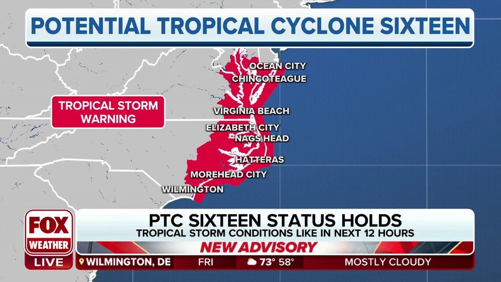
Tropical Storm Warnings in effect from North Carolina to Delaware as Potential Tropical Cyclone 16 aims for East Coast.
Tropical Storm Warnings are in effect from North Carolina to Delaware as Potential Tropical Cyclone 16 aims for the East Coast. The system has gained some organization overnight, with the winds stronger, but lacks a definitive center.
Updated 9:30 a.m. ET Friday
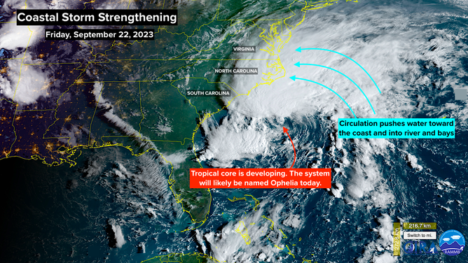
The non-tropical low-pressure system off the Carolina coast is strengthening. The out-of-season nor’easter-type storm developed yesterday off Florida. Now it’s strengthening as it heads toward North Carolina and a track that will affect most of the East Coast of the U.S. over the weekend.
It was labeled Potential Tropical Cyclone SIXTEEN by the National Hurricane Center because it wasn’t technically a tropical system, but could develop into one. Nor’easters are powered by cold and warm air in the atmosphere, while tropical systems get their energy from the warmth of the ocean. This one formed from a combination of a front across Florida and a strong upper-air disturbance. The system was shaped like a giant comma with no defined center of circulation.
Once it got spinning and moving, it tracked over increasingly warm Gulf Stream water, which is allowing it to form a core more like a tropical system. Unlike a hurricane, however, the strongest winds will likely be focused well north of the center, not in a donut around the eye.
There is a good chance the system will be named Subtropical Storm Ophelia today, before it reaches the North Carolina coast. A subtropical storm is a hybrid of a nor’easter and a tropical system where the strongest winds are well displaced from the center. There’s even some chance it could become fully tropical with an organized core. But in the end, the technicalities won’t make much difference to the weather expected along the coast.
An extended period of strong onshore winds will push ocean water into the inlets, sounds, rivers, and bays from North Carolina to New Jersey. The National Hurricane Center is forecasting 3 to 5 feet of water above normal high tide in the rivers that run into the southern part of Pamlico Sound around Cape Hatteras. A water rise of up to 4 feet is forecast for many waterways, sounds, and bays near the Cape and in and around the Chesapeake Bay.
(FOX Weather)
Everyone on or near the Carolina or Mid-Atlantic coast should be sure to know the tide cycle where they are. Low-lying areas may be flooded, and marine interests will have to take action.
Winds will likely gust to 60 mph along the coast in bands of heavy rain as the system tracks slowly to the north. The areal coverage of the rain will expand north well ahead of the center of the system.
On the current schedule, the rain and strongest winds move into the Carolinas today, spread across the Mid-Atlantic tonight and tomorrow, finally reaching New England by tomorrow afternoon. The system will weaken once it gets to the Northeast, but it is forecast to linger at least through Sunday, with nasty wet and windy weather only slowly abating.
Pay attention to local alerts and information along the coast, especially in vulnerable flood-prone areas near the water.
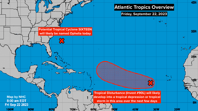
The Tropical Disturbance on the other side of the Atlantic – now officially tagged Invest #90L – is getting organized. The National Hurricane Center is giving it a high chance of developing into a tropical depression or tropical storm as it heads west in the general direction of the northeastern Caribbean islands.
(FOX Weather)
It would be named Tropical Storm Philippe, assuming the East Coast system ends up using Ophelia.
The consensus of the long-range computer forecasts is that the storm will turn to the north before it gets to the islands, though that’s not 100%. As always, forecasts for just-developing systems are subject to change, so everybody in Puerto Rico and the surrounding islands should stay informed. On the current schedule, the system would be near the northeastern-most islands on Wednesday or Thursday of next week.
Nothing else is cooking at the moment, but there’s obviously a good ways to go.