Bryan Norcross: Philippe to merge with non-tropical system, head toward Maine and Atlantic Canada
Gusty winds and tropical squalls will impact Bermuda today until the combo system moves by tonight. By tomorrow, the system will become a large coastal low – like a nor’easter – and head toward eastern Maine and Atlantic Canada. Impacts begin there tomorrow.

FOX Weather is your Hurricane HQ, streaming free 24/7.
Updated 9 a.m. ET Friday
What’s left of Tropical Storm Philippe is merging with a large, complex, non-tropical system just to its west.
Gusty winds and tropical squalls will impact Bermuda today until the combo system moves by tonight. By tomorrow, the system will become a large coastal low – like a nor’easter – and head toward eastern Maine and Atlantic Canada. Impacts begin there tomorrow.
Strong winds gusting over hurricane force, especially to the right of where the center of the low-pressure area/coastal storm comes ashore with heavy tropical rains expected.
Dangerous surf driven by strong ocean swells generated by Philippe will impact the U.S. East Coast as the storm moves north.
Another player in the impacts in New England and Atlantic Canada is a strong cold front, which will move into the Northeast today and meet the storm in northern New England about the time it makes landfall. The front will bring its own moisture and wind energy with it.
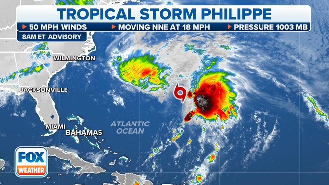
Tropical Storm Philippe's stats.
(FOX Weather)
The net result will be rain from the front along the I-95 corridor in the Mid-Atlantic and Northeast today into tomorrow, with heavier rain and stronger wind in New England tomorrow into Sunday as the combo coastal storm and front meet.
As everything with Philippe has been so far, the meteorology is messy. A sharp dip in the jet stream off the Florida and Southeast coasts is scooping up Philippe and moving it north. In addition, a non-tropical low-pressure system is developing just west of Philippe, spawned by the jet-stream dip.
The development of a low-pressure center related to a jet-stream dip is the usual way coastal storms form in the winter. What’s unusual with this situation is that there’s a tropical storm in the mix.
So, the strong jet-stream dip is scooping both Philippe and the non-tropical low to the north, along with the tropical moisture from the Caribbean. The two low-pressure centers will initially wrestle and then kiss, make up, and merge as they head toward landfall on Saturday.
Since the final system is forecast to resemble a typical wintertime coastal low when it reaches Maine, New Brunswick, and Nova Scotia, the current plan from the National Hurricane Center and Environment Canada is to issue standard weather alerts for the impacts, not tropical storm warnings. People in that area are more familiar with the alerts they receive for strong coastal storms several times a year, and this combo-system’s impacts will be the same.
The weather will clear from south to north late Saturday through Sunday as cool, dry air behind the front blows in.
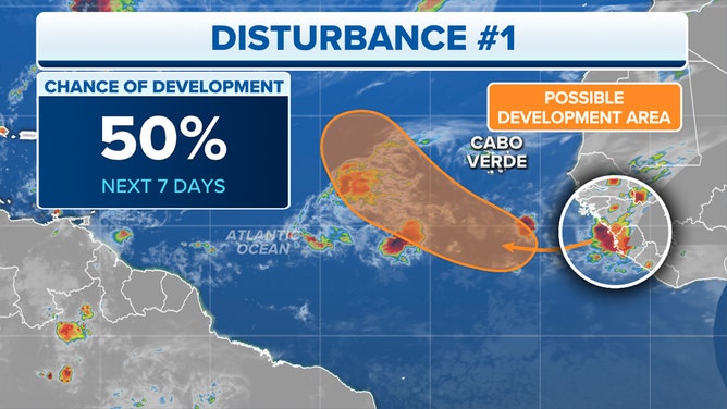
A potential tropical disturbance will emerge off Africa.
(FOX Weather)
On the coast of Africa, a disturbance is emerging into the Atlantic. The National Hurricane Center gives it a medium chance of developing over the tropical ocean in a few days. There is no indication that it will threaten land, but we’ll keep an eye on it next week to be sure.
The south end of the strong front that is merging with the Philippe combo system over New England will lodge across the Gulf of Mexico. Late next week, the tail of the front might become the seed for a low-pressure system to develop. It’s just something to keep an eye on.