Bryan Norcross: Philippe is sputtering in the central Atlantic with eventual-Rina, Invest 91L next in line
he tropical disturbance behind Philippe, officially tagged Invest 91L, is just in its organizing stage. In a day or two, however, the atmospheric pattern looks conducive for the system to develop into a tropical depression or Tropical Storm Rina.

FOX Weather is your Hurricane HQ, streaming free 24/7.
(FOX Weather / FOX Weather)
Updated at 8:45 a.m. EDT on Tuesday
Tropical Storm Philippe is in rough shape, and its road ahead looks rough. The storm is trudging forward across the tropical Atlantic into hostile upper-level winds and increasingly dry air. Some computer forecasts lift it north, but more now weaken it further and show it eventually moving into waters north of Puerto Rico and the surrounding islands.
The question is, how badly will the hostile upper winds and dry air wound the system? The good news is that it appears that Philippe will be very weak or just a remnant disturbance if it directly affects the islands. If it maintains strong, tall thunderstorms in its circulation, it will likely turn north, but that’s looking like a low-odds possibility now.
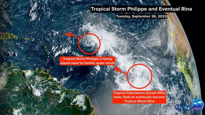
A satellite image of Tropical Storm Philippe and Invest 91L on Tuesday, September 26, 2023.
(NOAA)
The National Hurricane Center’s official forecast shows Philippe continuing to weaken as its track bends west into the waters north of the Caribbean. Since the track seems to be dependent on the intensity, which itself is a balancing act between hostile and conducive forces, the outcome is more uncertain than normal. But the odds are high that Philippe won’t be a significant threat to the islands.
The tropical disturbance behind Philippe, officially tagged Invest 91L, is just in its organizing stage. In a day or two, however, the atmospheric pattern looks conducive for the system to develop into a tropical depression or Tropical Storm Rina. The name Rina, by the way, replaced Rita, which was part of the epic Category 5 trifecta of Katrina, Rita and Wilma in the marathon hurricane season of 2005.
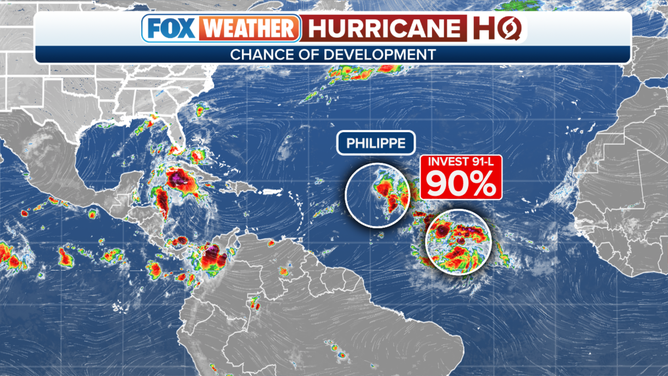
An overview of the tropical Atlantic Ocean on Tuesday, September 26, 2023.
(FOX Weather)
The consensus of the long-range computer models is that eventual-Rina will likely intensify and turn north well before the islands, although its future track also appears dependent on how strong it gets, with a weaker system coming closer to the Caribbean.
A strong dip in the jet stream now over the Upper Midwest should meet likely-Rina in the central Atlantic in a few days and tug it north. Since the system is still developing, the forecast could change, of course. So we’ll have to see how strong Rina gets once it organizes and gets named.
Nothing else looks to be cooking. But deep dips in the jet stream are forecast over Florida and the eastern U.S. in the next couple of weeks, which can draw tropical systems north, so we’ll watch for that.