Bryan Norcross: New forecasts show track farther offshore of New England for Hurricane Lee
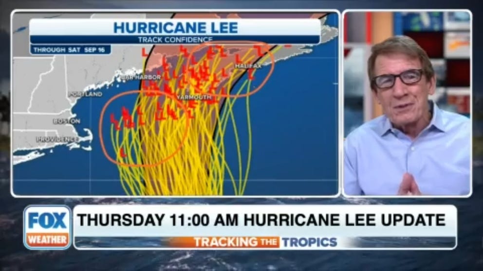
The latest forecasts from the National Hurricane Center and the various computer models show a track a little farther offshore of Rhode Island, Massachusetts, and southern Maine than they did yesterday. However, the northern part of Maine – Downeast Maine – still extends east toward the storm's forecast track.
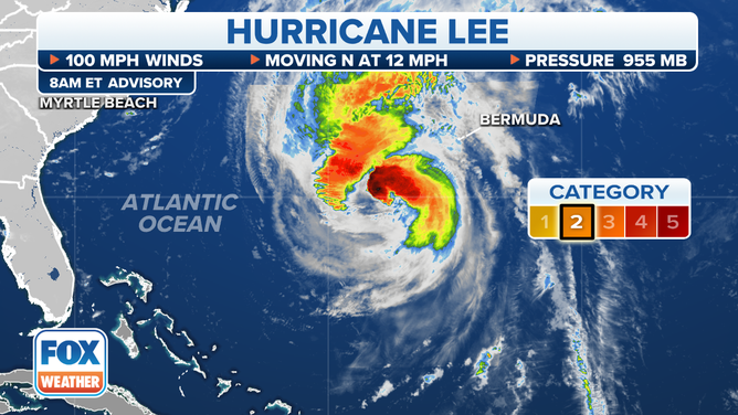
Bryan Norcross exclusive analysis: Hurricane Lee's latest advisory information
Bryan Norcross breaks down the latest advisory on Hurricane Lee as the storm moves north.
Updated at 8:45 a.m. ET Thursday
It's clear that Hurricane Lee will be felt in New England. The question is only how severe the impacts will be. The latest forecasts from the National Hurricane Center and the various computer models show a track a little farther offshore of Rhode Island, Massachusetts, and southern Maine than they did yesterday. However, the northern part of Maine – Downeast Maine – still extends east toward the storm's forecast track.
Offshore is better than onshore, of course. And well offshore is better yet. This is another situation where slight changes can make a lot of difference, so the only course of action is to stay informed as updated forecasts are issued.
On the current schedule, the storm will arrive in the vicinity of New England tomorrow evening and be closest to Cape Cod Saturday morning. As we have all seen, forecasts can change in a day and a half. In this case, the storm is in a well-established river of air flowing north. However, so big changes don't appear likely. Although, it would only take a big wobble to the left to bring dangerous weather over the highly populated I-95/I-93 corridor, which can't be ruled out.
It is evident that Hurricane Lee will affect New England. The only question is the severity of its impacts.
(FOX Weather)
Because we can't be 100% sure how far offshore Hurricane Lee will track, and northern Maine continues to be in the threat zone, the National Hurricane Center has issued Hurricane Watches for Downeast Maine and Tropical Storm Watches for the New England coast from Rhode Island north. The biggest threat of strong winds and heavy rain is on Cape Cod and in Downeast Maine – the part of Maine that borders Canada.
Warnings might be issued today for some of those areas. Watches and Warnings can be a bit confusing because people focus on the time aspect of the alerts. Watches are issued about 48 hours before winds of 40 mph could arrive, and warnings come at 36 hours. But there is also the likelihood component. Watches mean that winds of tropical storm force (40+ mph) or hurricane force (75+ mph) are POSSIBLE. Even in a shorter time frame, there can be areas where the winds are possible, but not especially likely.
In any case, if you live in an area where these wind alerts are in effect, prepare for power outages – have enough supplies at home. Also, don't park your car under a tree.
Forecasts of elevated ocean levels were issued Wednesday for all of New England plus Long Island, New York. In most areas, the expectation is that the ocean water rise will be limited to at most 2 or 3 feet above normal high tide. The exception is in Cape Cod Bay, the body of water surrounded on the west, south, and east by Cape Cod and southeastern Massachusetts. With the wind pushing the ocean into the bay from the north, water levels could reach 4 feet above normal high tide. Because the forecast is for over 3 feet, a Storm Surge Watch was issued for that area.
Currently, it looks like the peak push of water into Cape Cod Bay will occur around Saturday morning low tide, which would mitigate the threat. But we can't be 100% sure about that timing. Plan for some elevated water near the coast for the next few days.
Because Hurricane Lee is so big across, its broad sweep of wind is putting a lot of energy into the Atlantic. At the coast, the waves will break with extra intensity, which, along with the slightly elevated water levels, can cause beach erosion. Also, surf and near-shore waters will be very dangerous in the Northeast and New England into the weekend.
For the next few days, pay extra attention to weather alerts and instructions for your area from emergency officials. Just to be sure nothing weird happens.
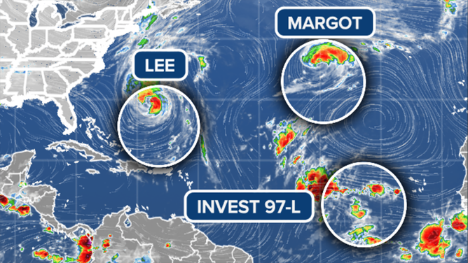
Hurricane Margot in the Atlantic is moving away from land and weakening.
(FOX Weather)
Out in the Atlantic, Hurricane Margot is slowly sliding toward its demise. It will not threaten land.
In the tropical, the Tropical Disturbance that's officially tagged Invest #97L is showing signs of organization. It has a good chance of becoming Tropical Storm Nigel in the next few days. Likely-Nigel is forecast by the computer forecast models to initially follow Lee more-or-less. There is no indication of a threat to land, however. Though it will bear watching to be sure.