Bryan Norcross: Keeping an eye on the Caribbean for a possible Gulf threat while Franklin gets stronger
In the eastern Atlantic, two systems have a good chance of organizing. Neither will be a threat to land. For now, plan to watch the Caribbean for a potential Gulf threat.

FOX Weather is your Hurricane HQ, streaming free 24/7.
(FOX Weather / FOX Weather)
UPDATED Thursday at 9 a.m. ET
Social media has been buzzing about the idea of a storm in the eastern Gulf of Mexico next week. Indeed, some computer forecasts have shown a disturbance moving north from Central America, developing into a storm, and threatening the west coast of Florida.
The National Hurricane Center is painting an area from the western Caribbean into the Gulf of Mexico as the potential development area over the next several days – giving it a medium chance of becoming at least a tropical depression.
The system in question is a disturbance near the Pacific coast of Nicaragua. The other player in the scenario is an upper-level low-pressure center moving across the southern Gulf of Mexico. The rotation around that upper low will act as a scoop to pull the disturbance and/or its moisture across Central America into the Caribbean and push it in the direction of the Gulf.
Satellite images show the disturbances being tracked in the Atlantic.
(NOAA)
There is reasonable consensus on the first part of that process. The question after that is, does the weather pattern in the Gulf – the upper wind regime – support the development of the system or not? Currently, there is violent disagreement among the computer forecast models on that question.
The National Hurricane Center is taking a middle-ground approach, acknowledging the possibility but not committing to any specific outcome.
If the European computer forecast is correct and a system organizes, we should see it over the weekend in the western Caribbean. If it were to develop, we would have a short time window to prepare in Florida. On the current schedule, the system would be in the vicinity of the west coast about Tuesday, plus or minus.
The extreme disagreement in the computer models has to do with how they treat the upper-level winds. Over most of the Gulf, the environment looks generally hostile. It is possible, however, that a sliver of conducive atmosphere could develop in the eastern Gulf, allowing the system to organize and strengthen to one degree or another.
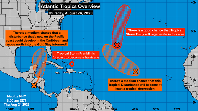
National Hurricane Center tropics overview for Aug. 24, 2023.
(NOAA)
It’s all "could" and "maybe" at this time, but the west coast of Florida is, obviously, an especially vulnerable place, so we pay extra attention when a possibly threatening scenario is developing.
This type of scenario is not uncommon, although most often, it’s more likely to happen in June or October than in August. For now, think about your hurricane plans in Florida, just in case. And plan to stay informed over the weekend.
Tropical Storm Franklin is slowly pulling away from the Dominican Republic. The moisture feed will gradually decrease in intensity across the islands, but some additional rain is still in the forecast.
Franklin is forecast to become a hurricane well away from Puerto Rico and then head to the north. The atmosphere looks conducive for the system to intensify as it moves to the vicinity of Bermuda early next week. Folks in Bermuda will have to stay aware of the latest forecasts over the weekend, though the consensus at this point is that the storm will stay well offshore.
In the eastern Atlantic, two systems have a good chance of organizing. Neither will be a threat to land.
For now, plan to watch the Caribbean for a potential Gulf threat.