Bryan Norcross: Caribbean disturbance Invest 97L looks likely to develop this week
The disturbance is currently under somewhat hostile upper-level winds, so any development is expected to be slow. As it moves west toward Central America, however, the atmospheric environment is forecast to become more conducive for the system to organize.

FOX Weather is your Hurricane HQ, streaming free 24/7.
(FOX Weather)
Updated Tuesday 9 a.m. ET
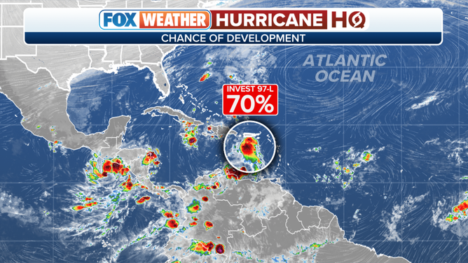
The large area of disturbed weather in the eastern Caribbean Sea has been officially tagged Invest 97L.
The disturbance is currently under somewhat hostile upper-level winds, so any development is expected to be slow. As it moves west toward Central America, however, the atmospheric environment is forecast to become more conducive for the system to organize.
The National Hurricane Center is giving the disturbance a low chance of developing into at least a tropical depression over the next couple of days, but a high chance later in the week.
The water in the Caribbean is extremely warm this year, so there’s plenty of fuel to power the system. The limiting factor would seem to be the amount of time it has under supportive enough winds to develop.
An overview of the tropics in the Atlantic Basin.
(FOX Weather)
If winds in the circulation reach 40 mph or higher, it will be named Tropical Storm Vince.
On the current schedule, the system would impact Central America around the weekend. Even if the system doesn’t get very strong, dangerous flooding rains appear likely.
A blocking bubble of high pressure is forecast to maintain its position between Florida and the Caribbean, which should keep the system from turning north. There’s no indication at the current time of any threat to Florida or surrounding areas.
Residents in the Caribbean coastal areas of Nicaragua, Honduras, Belize, and Mexico should stay informed this week as we see how the system develops.
Except for this narrow corridor in the Caribbean, a wintertime weather pattern hostile to development is blanketing the tropics.