Indications that the tropics will finally heat up next week
People in the northeastern Caribbean islands should stay aware of developments with this system, since it won’t be far away from them when it develops, if it does.
The podcast Tracking the Tropics with Bryan Norcross is now available to stream.
(FOX Weather)
Updated at 8:20 a.m. EDT
Don’t get complacent. The long-range computer forecast models indicate that the factor or factors that have been keeping tropical activity unusually quiet will begin to let up around the middle of next week.
The National Hurricane Center has been following two tropical disturbances – each complex in its own way.
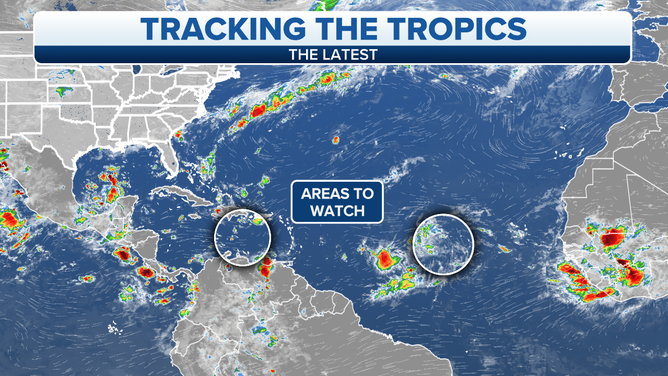
The circled areas are currently being monitored in the Atlantic Basin by the National Hurricane Center.
(FOX Weather)
Tropical Disturbance #1 is a disorganized, barely noticeable cluster of showers moving west through the Caribbean. Nothing will happen right away, but when it gets to the western Caribbean around the middle of next week, a system to the south might come into play.
HOW TO WATCH FOX WEATHER ON TV
A broad area of low-pressure over and near Central America might combine with the disturbance to produce an organized system late next week in the western Caribbean. There are a lot of ifs and maybes involved, but it’s not an unheard-of scenario. Quite often, a tropical disturbance triggers development in a cluster of moisture being pulled up from the south.
There are no signs of anything yet. It’s mostly computer forecast model speculation. If something develops, the system might be approaching the Yucatán peninsula of Mexico. People there should say aware.
Tropical Disturbance #2 is more likely to develop based on the latest computer forecast models and the National Hurricane Center forecast. It’s comprised of a typical disturbance that originated over Africa, which has loosely combined with a disturbance to the south in a large, complex area of low pressure. The lack of consolidation of the system implies that it will take longer to organize, if it does. But there might be enough moisture in the combo system to fight off the dry air over the Atlantic, which the system will have to overcome to develop.
Again, nothing is expected to happen for the next couple of days, but by midweek, the forecast atmospheric environment looks more supportive of tropical development, although dry air remains in the area. If an organized system does develop, it will still be a very close call whether it can become a named storm before August ends on Wednesday.
A storm-free August is almost unheard of. But it doesn’t mean that September can’t be busy.
People in the northeastern Caribbean islands should stay aware of developments with this system, since it won’t be far away from them when it develops, if it does.
FOX Weather Hurricane Specialist Bryan Norcross has a podcast, Tracking the Tropics with Bryan Norcross, available now on FOX News Audio. You can get it on your device by clicking here.