Bryan Norcross: Hurricane Tammy to swipe the northeastern Caribbean islands Saturday
So far, the strongest winds are just offshore, but the slightest jog to the left will bring hurricane-force winds over some islands and tropical-storm-force winds over more.

FOX Weather is your Hurricane HQ, streaming free 24/7.
(FOX Weather)
Updated Saturday at 9:40 a.m. ET
The center of Hurricane Tammy is tracking north just east of the Leeward Islands in the northeast Caribbean. So far, the strongest winds are just offshore, but the slightest jog to the left will bring hurricane-force winds over some islands and tropical-storm-force winds over more.
Rainfall will be heavy on affected islands. The storm is shaped like a giant comma, and gusty squalls that could cause torrential downpours are in the tail as well as the comma head. In addition, there is a big blob of tropical moisture and embedded heavy thunderstorms to the south. All three parts of the Tammy complex – the head, the tail, and the blob – will move north today and the first part of tomorrow.
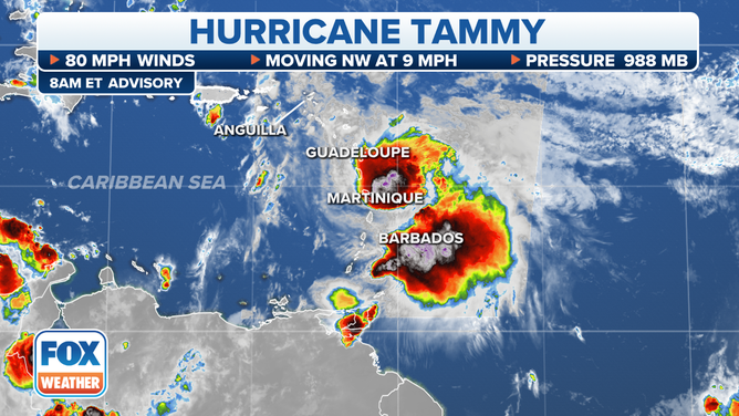
The center of Hurricane Tammy is tracking north just east of the Leeward Islands in the northeast Caribbean.
(FOX Weather)
An additional player is an upper-level low-pressure system that has been sitting in the vicinity of Puerto Rico for the last couple of days. This system is causing slightly hostile upper winds that are helping keep Tammy from strengthening significantly. Its presence also means that the atmospheric environment over the northeastern Caribbean supports heavy rain. So tropical downpours are possible even outside of the areas directly affected by Tammy.
Everyone in Puerto Rico and around the Lesser Antilles that stretch the length of the eastern Caribbean has the possibility of being affected by some part of Tammy or the enhanced rain threat of the upper low. In all cases, gusty tropical downpours are possible. The National Hurricane Center is forecasting 4 to 8 inches on the affected islands, with some local amounts reaching 12 inches.
After Tammy’s center moves well north of the islands by late tomorrow, moisture is forecast to linger over the islands, so the heavy-rain threat will continue in some areas, especially where the wind is blowing onshore and interacting with high terrain.
Exactly what happens to Tammy early next week is unclear. The various computer forecasts are in violent disagreement. It looks likely that Tammy will stall or meander over the open Atlantic well north of the Caribbean for a while. Bermuda might have to watch it for later in the week. It’s also possible that it gets absorbed into another disturbance that eventually migrates west.
We’ll see. Nothing will happen fast. When a system stalls, forecasts become much more uncertain.
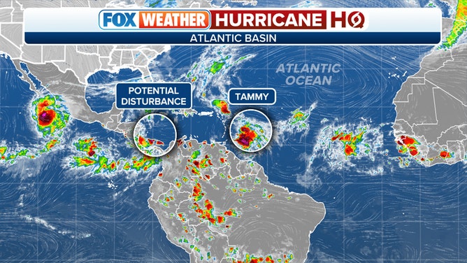
A look at what's being monitored in the Atlantic basin.
(FOX Weather)
In the extreme southern Caribbean, the National Hurricane Center is pointing to an area of disturbed weather. The blow-up of thunderstorms is related to a broad low-pressure system that straddles Central America. There is a slight chance something could develop here, but the time window is short. The disturbance will move over land in a day or two.
Looking downstream, we’ll watch the remnants of Tammy, although there is no explicit threat for now. And as long as cold fronts keep pushing through Florida, we have good protection for the U.S. and surrounding areas.