Hurricane Lisa to make landfall today – plus a new area to watch near the Bahamas
Lisa was upgraded to a hurricane this morning, and Martin is expected to reach hurricane strength later today as it heads into the North Atlantic. If that pans out, we will be at 13 named storms, including 7 hurricanes for the season.
The podcast Tracking the Tropics with Bryan Norcross is now available to stream.
(FOX Weather)
Updated at 9 a.m. Eastern
Mother Nature is trying to make up for lost time filling out the list of storms this hurricane season. Lisa was upgraded to a hurricane this morning, and Martin is expected to reach hurricane strength later today as it heads into the North Atlantic. If that pans out, we will be at 13 named storms, including 7 hurricanes for the season.
Based on the 30-year averages from 1991 to 2020, a normal season has 14 named storms and 7 hurricanes, so we’re close. And another oddball scenario might develop next week to add a name to the list.
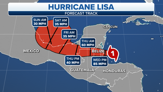
A graphic showing the latest forecast track for Hurricane Lisa.
(FOX Weather)
Hurricane Lisa is bearing down on Belize. The center is expected to make landfall late this afternoon or this evening in the vicinity of Belize City, plus or minus. Lisa will likely come ashore as a Category 1 hurricane, but residents should prepare for a Category 2.
The water will rise on the entire coastlines of Honduras, Belize, and the Caribbean coast of Yucatán Mexico, but the highest water will be to the north of where the eye comes ashore. The National Hurricane Center is forecasting up to 7 feet of water rise pushed against the islands and coastal sections north of the landfall point in Belize and into Mexico.
Flooding rain will also be an issue. Local areas could receive up to 10 inches across the region, with widespread totals of 4 to 6 inches.
HOW TO WATCH FOX WEATHER ON TV
Talk about hurricanes and Belize City makes everybody nervous there. In 1961, Category 4 Hurricane Hattie largely destroyed the city, which was the capital of British Honduras at the time. A new capital was rebuilt in another city well inland.
This storm will not be another Hurricane Hattie, however. Lisa is an entirely different scale of hurricane, although it can still be deadly for people who stay in low-lying areas near or north of the landfall location.
Lisa will quickly weaken after it moves inland, although the heavy rain will continue.
In a couple of days, what’s left of the circulation is forecast to reach the extreme southern part of the Gulf of Mexico and stall. The upper-level winds are forecast to be hostile at that time, so the system is forecast to eventually die out as it drifts around over the Gulf or perhaps over southern Mexico or Guatemala.
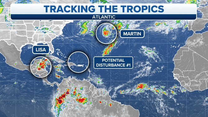
A graphic showing an overview of the tropical Atlantic Ocean.
(FOX Weather)
In the central Atlantic Ocean, Tropical Storm Martin looks likely to become a hurricane soon. It’s being powered by an unusually warm tongue of water east of Bermuda. The storm is forecast to turn into the North Atlantic and eventually become part of a giant wintertime storm southeast of Greenland.
Potential Disturbance #1 doesn’t yet exist, but the computer forecast models insist that a broad, complex low-pressure system will develop somewhere near or north of Puerto Rico in the next few days. The steering around an oddly large and intense upper-level disturbance drifting over the Bahamas and Florida should pull the disturbance to the north.
Whether the system starts out tropical or not is an open question, but as it moves north, it has a chance of developing some tropical characteristics. Because the weather pattern has wintertime aspects to it, nothing strong is likely to develop. But the contrast between strong high pressure over Canada and whatever low-pressure disturbance develops might produce strong onshore winds along a large part of the Southeast and Mid-Atlantic coast next week.
Everything about this potential disturbance is likely to change since the weather pattern that would trigger it hasn’t even developed yet. Stay tuned.
FOX Weather Hurricane Specialist Bryan Norcross has a podcast, Tracking the Tropics with Bryan Norcross, available now on FOX News Audio. You can get it on your device by clicking here.