Bryan Norcross: Hurricane Lee to generate powerful swells impacting East Coast next week
The thinking now is that Lee will be at Category 2 or 3 strength through the weekend. Some computer forecasts show the environment becoming more conducive for strengthening at the beginning of the week, so the National Hurricane Center is showing reintensification at that time.

FOX Weather is your Hurricane HQ, streaming free 24/7.
(FOX Weather)
UPDATED Saturday at 9:30 a.m. ET
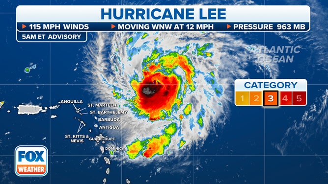
Hurricane Lee has been sputtering. The former Category 5 ran into an unexpectedly hostile patch of atmosphere yesterday, and the strong upper winds continue to impact the core of the storm.
The thinking now is that Lee will be at Category 2 or 3 strength through the weekend. Some computer forecasts show the environment becoming more conducive for strengthening at the beginning of the week, so the National Hurricane Center is showing reintensification at that time.
In any case, Lee will crawl across the waters north of Puerto Rico and the nearby islands until the middle of next week. The only concern for Puerto Rico and the surrounding islands is the energy that Lee will put in the ocean water directed toward the north-facing beaches, inlets, and waterways.
(FOX Weather)
There is high confidence that the hurricane will turn north about Wednesday. The uncertainty is exactly where the center of the storm will be at that time. If it moves slowly, it will likely stay farther offshore of the U.S. East Coast. If it moves at a deliberate pace, the turn will come closer to the Bahamas, and the potential threat to northern New England and Atlantic Canada is greater. The National Hurricane Center chose a middle position for the center of the cone, encompassing both possibilities.
In any case, Lee-powered swells will begin affecting the Southeast coast of the U.S. this weekend. The strength of the swells and the impact of the waves and undertow will increase significantly next week. On the current schedule, the peak push of water affecting the Southeast arrives about Wednesday, and then it surges north through the Mid-Atlantic to the Northeast and New England Thursday into next weekend.
Ignore nonsensical headlines about a monster hurricane slamming into New York City or Boston. That has never been that expectation. But coastal sections of the entire East Coast, and especially from North Carolina to Maine, could feel significant impacts, including beach erosion from large waves and strong currents. The magnitude will depend on how far offshore the storm tracks.
Some significant impact from winds along the coast can’t be completely ruled out in about a week, but that’s outside our reasonable forecast window, and most of the long-range projections keep the center of the storm offshore. As often is the case, when storms move slowly as this one will over the weekend, the forecast after that period has more uncertainty.
To reduce anxiety, it’s a good plan to focus on forecasts for the next five days. Projections farther in advance should only be used for awareness.
For now, people near the beach and marine interests should plan to stay informed on the track of Lee. Bermuda is well within the potential impact zone as well. The timetable for impacts there is the second half of next week – subject to change.
In the eastern Atlantic, Tropical Storm Margot is disorganized, but it’s still forecast to eventually become a hurricane as it heads north into the open ocean. It’s not a threat to land.
An African disturbance will have a chance to organize in several days, but it doesn’t look like a threat at the current time.