Bryan Norcross: Hurricane Lee strengthens into Category 5 while questions remain about impact on East Coast
Winds are forecast to remain at Category 5 strength through the weekend over extremely warm ocean waters and under super-conducive atmospheric conditions.

FOX Weather is your Hurricane HQ, streaming free 24/7.
(FOX Weather)
UPDATED Friday at 8:30 a.m. ET
Hurricane Lee went through explosive intensification to rapidly reach Category 5 strength. Thankfully, it’s going to miss the Caribbean islands to the north, although the strong winds will create dangerous conditions in the nearby ocean waters. Waves of 10 to 15 feet on the north-facing beaches are forecast in the islands.
Winds are forecast to remain at Category 5 strength through the weekend over extremely warm ocean waters and under super-conducive atmospheric conditions.
Even early next week, Lee is forecast to remain a powerful hurricane as it slows to a crawl in the waters north of the Caribbean islands and east of the Bahamas. About Wednesday, a dip in the jet stream moving across the eastern U.S. should start to scoop up the storm and pull it north.
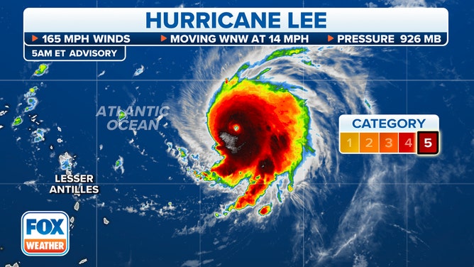
According to the National Hurricane Center, Hurricane Lee is less than 700 miles to the east of the northern Leeward Islands.
(FOX Weather)
Energy from the large, powerful hurricane will reach the beaches all along the East Coast of the U.S. late in the weekend with elevated water levels, dangerous waves, and powerful swells. Coastal impacts will increase in the Southeast Monday into Tuesday with extremely strong undertows and life-threatening rip currents in the ocean.
Once Lee starts to move around midweek, a path generally to the north until at least about Friday appears likely. Bermuda will be on alert. Lee will likely come close enough to impact the island, but it’s too soon to know to what degree.
By Thursday, the peak energy in the ocean should begin to reach the coast from the Mid-Atlantic to New England. Large, dangerous waves with powerful currents are likely into the weekend and possibly longer. Beach erosion is possible. Stay informed as the situation unfolds along the Northeast coast.
Late in the week, the forecast for the location of the center of the storm gets murky. The jet-stream scoop might not be strong enough to grab hold of Hurricane Lee and propel it out to sea. If it has to wait for another scoop to come along, increased coastal impacts in the Northeast and New England are possible. It’s too early to know precisely how the location and strength of Lee and the strength and orientation of the jet-stream dip will play out a week from now.
In any case, significant coastal impacts along much of the East Coast, and especially from North Carolina north appear likely.
In the eastern Atlantic, Tropical Storm Margot is on its way to becoming a hurricane. Margot is expected to drift around in the no-man’s land of the eastern or central Atlantic. No land appears threatened.
The disturbance just moving off Africa will run into somewhat hostile atmospheric conditions as it ventures into the Atlantic. There is no indication it will be a threat, at least for now.