Hurricane Fiona threatens Bermuda while another disturbance in the Atlantic has our attention
Fiona is forecast to continue to intensify as it heads in the general direction of Bermuda. The consensus of the computer forecast models and the official National Hurricane Center forecast shows the storm's center passing just west of the island beginning late Thursday into Friday.
The podcast Tracking the Tropics with Bryan Norcross is now available to stream.
(FOX Weather)
Updated at 9:40 a.m. EDT
Category 3 Hurricane Fiona will move away from the Turks and Caicos Islands today after battering those islands.
The center of the Fiona came within 10 miles of Grand Turk as it passed by just to the east. There is, no doubt, significant damage there. The circulation around Fiona also pushed storm surge against the northern side of the Caicos Islands, which are farther west. Tides of 5 to 8 feet above normal were forecast along those beachfronts full of hotels and resorts.
Tropical downpours are still likely in Puerto Rico today. Although the coverage of the rain is diminishing, the thunderstorms will continue to be quite intense where they occur due to a continued moisture flow wrapping into Fiona. Even more moisture is flowing over the eastern Dominican Republic. No fully dry day is forecast over the islands for the rest of the week.
HOW TO WATCH FOX WEATHER ON TV
Fiona is forecast to continue to intensify as it heads in the general direction of Bermuda. The consensus of the computer forecast models and the official National Hurricane Center forecast shows the storm's center passing just west of the island beginning late Thursday into Friday. Bermuda will be on the strong side of this hurricane, so full preparations will be required if nothing changes. The forecast has been very consistent and is high-confidence.
Fiona will then merge with a northern system and become a giant, powerful North Atlantic storm, which is forecast to impact Newfoundland and possibly Nova Scotia in Atlantic Canada over the weekend.
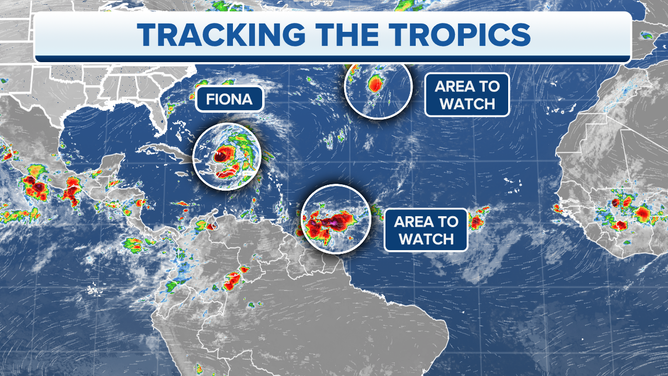
A map showing areas to watch for possible tropical development in the Atlantic Ocean.
(FOX Weather)
Tropical Disturbance #1 will move into the Caribbean Sea on Thursday and will likely command our full attention for a number of days. The weather pattern over the Caribbean is forecast to be conducive for the disturbance to develop into a tropical depression or stronger, especially when it gets closer to the western Caribbean.
The National Hurricane Center only has medium odds posted for the next five days, because the most likely development time would be just beyond that window.
The disturbance will move through the southern Caribbean islands on Thursday, likely as just a moisture surge. Then the question becomes whether and where it develops in the Caribbean.
The consensus of the long-range computer forecast models is that the system will eventually turn north toward Cuba and potentially Florida or the Bahamas, or it might wait longer and turn toward the Gulf of Mexico. This turn seems most likely to happen early next week, if it happens at all. The intensity of the storm at the point of the possible turn will affect the future track, and the intensity nearly a week in advance is unknown, of course.
The only thing to do at this point is to stay informed. If a storm does develop in the Caribbean, it could affect plans for this weekend or next week somewhere farther north.
The next two names on the list are Gaston and Hermine. If this system gets a name, it would likely be one of those. However, it's possible that Tropical Disturbance #2 could get a name first.
Tropical Disturbance #2 is showing signs of organization. Even if it does develop and get named, it is not expected to live very long. Although the system could affect the Azores in the northeastern Atlantic in a few days.
Elsewhere, nothing appears ready to develop.
FOX Weather Hurricane Specialist Bryan Norcross has a podcast, Tracking the Tropics with Bryan Norcross, available now on FOX News Audio. You can get it on your device by clicking here.