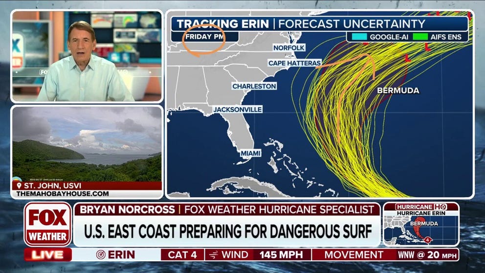
Bryan Norcross: Hurricane Erin explodes in size – still likely to avoid landfall but cause significant impacts
The dangerous conditions will start in Florida and on the Southeast coast on Tuesday, spreading to the Northeast and New England by Thursday. Beaches may be closed and boaters beware. Follow local instructions.
Bryan Norcross Exclusive Analysis: Hurricane Erin lashes Leeward Islands, brings dangerous conditions to U.S.
Hurricane Erin may cruise past the U.S. shoreline, but the Category 4 storm will create potentially dangerous conditions along the East Coast next week. FOX Weather Hurricane Specialist Bryan Norcross breaks it all down.
Posted Saturday at 9:30 AM E.T.
Hurricane Erin rapidly intensified overnight as it developed a small, symmetric core. The eye shrunk in size to about 9 miles, which has the equivalent effect to a figure skater drawing in their arms to spin faster. The National Hurricane Center had predicted rapid intensification with Erin, but it's happened ahead of schedule.
The storm has shed the dust and dry air that was limiting the intensification process and is moving over even warmer ocean water. The forecast calls for it to intensify a bit more – a Category 5 can't be ruled out – before the top winds come down and the storm grows in size as it turns north on a track offshore of the U.S. East Coast.
Erin's diameter is forecast to increase four- or five-fold over the next five or six days. Large hurricanes put much more energy into the ocean, so significant ocean impacts are expected along all coastal sections from the Bahamas to Canada, including, of course, the U.S. East Coast.
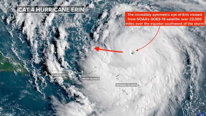
Hurricane Erin satellite image
(Bryan Norcross / NOAA)
Today, Erin will pass well to the north of Anguilla, St. Martin, and the nearby islands, with the center passing some 200 miles north of Puerto Rico and the Virgin Islands tomorrow. Tropical storm-force winds over 40 mph are only expected to extend about 140 miles south of the storm's center. Still, bands of rain will impact the islands.
Gusty squalls from feeder bands rotating into the hurricane will pass through the islands today and tomorrow. Winds could gust 40 to 50 mph, and intense downpours could cause flash flooding in mountainous terrain. The National Weather Service is forecasting 2 to 4 inches of rain with some areas receiving 6 inches or more. The gusts could cause some power outages.
On Puerto Rico and in the Virgin Islands, stay aware of alerts issued by the National Weather Service in San Juan.
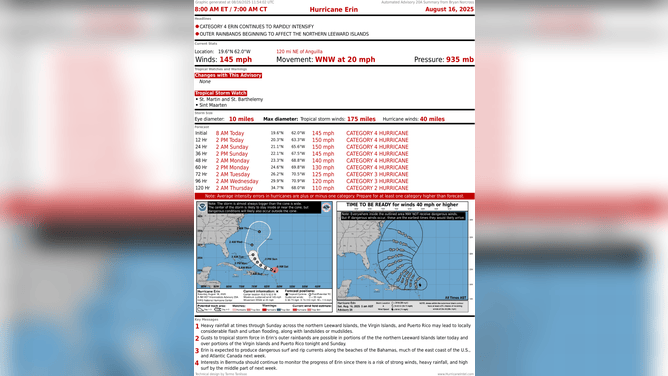
After Erin passes Puerto Rico tomorrow, it will arc north offshore of the Bahamas Monday and Tuesday. The weather pattern is forecast to be extremely supportive of an intense hurricane at that time - the ocean water is unusually warm east of the Bahamian Islands and the atmospheric pattern is forecast to be very supportive. As a result, Erin is forecast to be an extremely strong hurricane through this period, but with fluctuations in intensity due to internal processes within the storm.
By late Tuesday, Erin will have passed the Bahamas and will be heading north between the U.S. East Coast and Bermuda. Everyone is super lucky that this storm is threading the relative needle. But significant impacts will still be felt along the coast from Florida to New England.
Hurricane Erin's forecast cone and statistics
(Bryan Norcross / NOAA)
Expanding Hurricane Erin will generate huge waves in the open ocean and impart energy to the water that will radiate toward the coast in the form of strong, long-period swells. This energy will create powerful waves capable of eroding beaches and extremely strong and intense ocean currents.
The dangerous conditions will start in Florida and on the Southeast coast on Tuesday, spreading to the Northeast and New England by Thursday. Beaches may be closed and boaters beware. Follow local instructions.
Cape Hatteras, North Carolina is extremely vulnerable, of course. The National Hurricane Center will be analyzing the impacts to communities there and all along the coast and provide plenty of warning if action is required.
Bermuda will be on the strong side of the hurricane. Most likely, the worst of the storm will not impact the island, but significant effects can't be ruled out yet.
It is extremely fortuitous that the storm looks to pass through the gap between the Carolinas and Bermuda, though don't minimize the danger at the beaches and in waterways open to the Atlantic as the storm goes by.
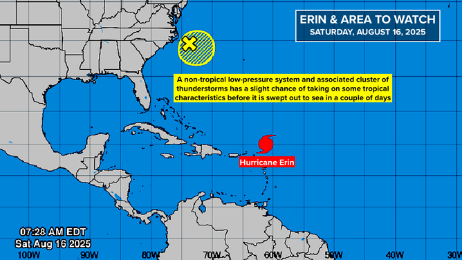
Off the Carolinas
The National Hurricane Center is painting a low-probability lemon offshore of Cape Hatteras, North Carolina. Once again, an old cold front is producing some thunderstorms over the Gulf Stream and there's a slight chance that a system could form that has enough tropical characteristics to be designated a depression. There is an outside chance it could briefly get strong enough to be named.
There is no threat to land, and the system will be heading out to sea over the next few days.
Atlantic tropical overview Aug. 16, 2025.
(Bryan Norcross / NOAA)
Next Thing to Watch
A disturbance that has just moved off Africa is forecast to track across the tropical Atlantic this week. There's reasonably good agreement in the various computer forecasts that it will arrive at the Caribbean islands at the end of the week. But there is no consensus on what will happen next.
Some computer forecast models develop it into a significant storm, which could be a threat to land. Others do essentially nothing with it. As always, forecasts are poor for systems that have not yet developed, so there's nothing to look at yet.