Bryan Norcross: Atlantic disturbance Invest 95L likely to develop this week
The National Hurricane Center now has the chance that the system will become at least a tropical depression in the high range. The computer forecasts generally agree that at least a depression is likely, but how strong the system eventually becomes is an open question.

FOX Weather is your Hurricane HQ.
(FOX Weather)
Updated at 10 a.m. ET on Sunday, Oct. 5, 2025
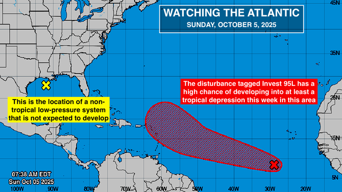
The National Hurricane Center has designated the tropical disturbance in the eastern Atlantic as Invest 95L. That just means we now have the hurricane-specific computer models running on the system. The strong consensus of the various computer forecasts is that the invest, or whatever it develops into, will be in the vicinity of the northeastern Caribbean islands east of Puerto Rico Thursday or Friday.
The NHC now has the chance that the system will become at least a tropical depression in the high range. The computer forecasts generally agree that at least a depression is likely, but how strong the system eventually becomes is an open question.
The possibilities range from a gusty disturbance to a hurricane. The Google DeepMind AI model gives us the odds of the various strength possibilities. Its strong consensus is that the system will only reach tropical storm strength. If it develops, its name will be Jerry.
This image provides an overview of the tropical Atlantic Basin on Oct. 5, 2025.
(FOX Weather)
The limiting factor appears to be dry air, which dominates the atmosphere over the tropical Atlantic. The atmospheric pattern around the system is forecast to be reasonably conducive for development, and the water is plenty warm.
The disturbance is relatively large, so development is likely to be slow and steady. As always, forecasts will become more reliable when and if the system acquires an organized circulation.
About the time the likely-storm reaches the vicinity of the northeast Caribbean Thursday or Friday, a strong dip in the jet stream is forecast to develop over the eastern U.S. once again. The strong consensus of the computer forecasts is that the depression or storm will be deflected north into the central Atlantic.
Obviously, we will keep an open mind about the long-range forecasts, but that is the universal consensus of the computer models as of now.
The National Hurricane Center is also noting the low-pressure system in the northwestern Gulf. It's a non-tropical system and is forecast to move to Texas. Enhanced rainfall along the Gulf Coast and some gusty winds are expected.
Otherwise, nothing appears to be brewing in the tropics.