Bryan Norcross: Tropical systems bracket Mexico as the Atlantic stays calm
Some of Tropical Depression Two's moisture will likely reach South Texas, bringing heavy rain beginning tonight into Monday, but the system will soon be history over mainland Mexico.

Could potential tropical development impact 4th of July holiday weekend plans?
A new area to watch for possible tropical development has emerged off the southeastern coast of the U.S., and it could impact Fourth of July holiday weekend plans. FOX Weather Hurricane Specialist Bryan Norcross breaks down the latest forecast on June 29, 2025.
In the extreme southwestern Gulf, Tropical Depression Two is heading toward the Mexican coast between Veracruz and Tampico. The system is very poorly organized, and there's a good chance it will come ashore as a blob of tropical moisture with some gusty winds.
If the circulation organizes before landfall late Sunday, and the winds increase slightly to at least 40 mph, the storm will be named Tropical Storm Barry. It’s unlikely to happen, but just in case, a Tropical Storm Warning is in effect for part of the Mexican Gulf coast.
The strongest winds, such as they are, will impact the coast mostly north of wherever landfall occurs. There will likely be some gusts in the 40-50 mph range, but the biggest threat will be flooding from heavy rain.
Some of the depression’s moisture will likely reach South Texas, bringing heavy rain beginning tonight into Monday, but the system will soon be history over mainland Mexico.
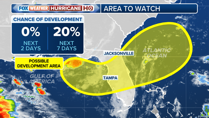
This graphic shows information on an area to watch for possible tropical development in the Gulf or off the southeastern coast of the U.S. later this week.
(FOX Weather)
On the Pacific side of Mexico, a separate, though loosely related, depression is on the way to becoming a tropical storm and likely Hurricane Flossie. It will track parallel to the southwestern Mexican coast this week.
The official forecast from the National Hurricane Center is for the worst of the winds to stay offshore, but a slight shift in the track would bring dangerous weather to the coast near Manzanillo. Residents there should stay informed.
Flossie should be weakening significantly by the end of the week as the system approaches the general area of Cabo San Lucas, but everybody around there should stay informed as well.
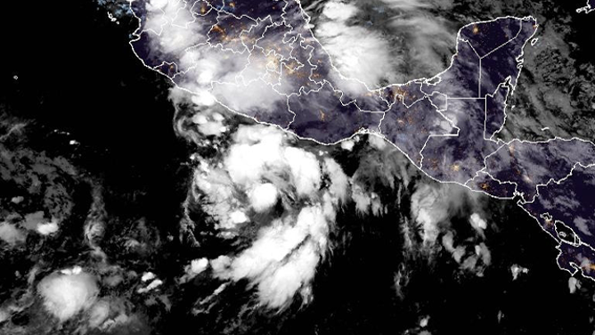
This satellite image shows Tropical Depression 6E in the Eastern Pacific on Sunday, June 29, 2025.
(NOAA)
The tropical Atlantic and the Caribbean show no signs of waking up. Strong winds, dry air including Saharan dust, and high pressure continue to dominate. Disturbances from Africa with their deep tropical moisture will continue to be pushed far west toward Mexico. The Pacific systems and the depression in the Gulf all developed due to this stubborn weather pattern.
Elsewhere, a cold front is forecast to stall out near the Florida/Georgia line next weekend. The shifting wind flow across a front can sometimes trigger a tropical system to start spinning. Some of the computer forecasts show the possibility of a depression forming in the northeastern Gulf or off the Georgia/Carolina coast around a week from now. It's something to keep an eye on, but nothing is going on yet. Systems that form from old fronts are often what we see in June.
Surges of Saharan dust are forecast to continue moving across the Atlantic to the Gulf for the foreseeable future. So the only development that’s likely involves fringe systems like we're seeing in the extreme southern Gulf or disturbances that form from dying fronts near the Gulf or Southeast coast.