Bryan Norcross: Local flash flooding is likely in southern Louisiana and parts of the Gulf Coast
The National Hurricane Center still has a low chance that the system will organize well enough to be deemed a tropical depression before it moves ashore.

FOX Weather is your Hurricane HQ.
(FOX Weather)
Updated at 10 a.m. ET on Thursday, July 17, 2025
The tropical disturbance we've been following in the northern Gulf is broad and disorganized. The ill-defined center will move into southeastern Louisiana today. Heavy, persistent rain will bring the threat of flash flooding across southern Louisiana and along the Gulf Coast.
A Flood Watch is in effect from the Mississippi coast across southern Louisiana. Widespread 2-6 inches of rain is forecast with some spots receiving a foot.
The center of the system is not relevant in terms of the location of the heaviest rain. Upper-level winds are pushing the largest area of rain west of the nominal center of the system. The air is already extremely humid along the Gulf Coast and the disturbance is carrying more tropical moisture with it. That guarantees that the rain that falls due to the proximity of the low-pressure system is going to be heavy.
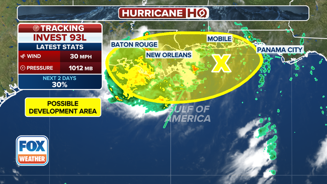
The development odds for Invest 93L along the Gulf Coast.
(FOX Weather)
The National Hurricane Center still has a low chance that the system will organize well enough to be deemed a tropical depression before it moves ashore. The hostile upper winds make that unlikely, however. Even if it did suddenly develop an organized circulation over the very warm Gulf waters between Louisiana and Mississippi, it would be short-lived, and the impacts from the system would be unchanged.
Stay aware of flooding alerts from the National Weather Service, and, of course, don't drive through flooded roads. You never know whether the road was washed out underneath the water you can see.
The blob of moisture is forecast to move toward Texas on Friday before the system dissipates. Some tropical thunderstorms are likely in East Texas.
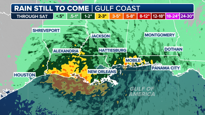
Rainfall forecast through Saturday, July 19, 2025.
(FOX Weather)
Nothing else is cooking across the tropics. We are still well ahead of schedule with named storms, and the first hurricane doesn't form, on average, until Aug. 11.
Water temperatures across most of the tropics are about average, plus or minus, so the season isn't primed for early development. In addition, dry air and dust dominate the tropical belt. Conditions are expected to continue in this mode through next week and probably for the rest of the month, although another disturbance like the one in the Gulf can never be ruled out.