Bryan Norcross: Long-range forecasts keep Hurricane Erin offshore, but US impacts expected
There is a plausible scenario that a strong Hurricane Erin's center will track close enough to Eastern North Carolina and New England to do more than just brush the coast next Wednesday and Thursday. That's not the most likely scenario, but it can't be completely ruled out at this point.
Bryan Norcross offers expert analysis on ‘pristine atmosphere’ for rapid intensification of Tropical Storm Erin
FOX weather Hurricane Specialist Bryan Norcross offers expert analysis of the latest forecast for Tropical Storm Erin, which is expected to become a hurricane by tomorrow and then rapidly intensify into a major hurricane this weekend.
Updated 09:30 a.m. ET on Aug. 14, 2025.
We’re doing another Hurricane HQ&A today – LIVE on Facebook, YouTube, TikTok, X, Instagram, and LinkedIn. If you have any questions about Erin or weather in general, send it in. I look forward to hearing from you.
The latest on Tropical Storm Erin
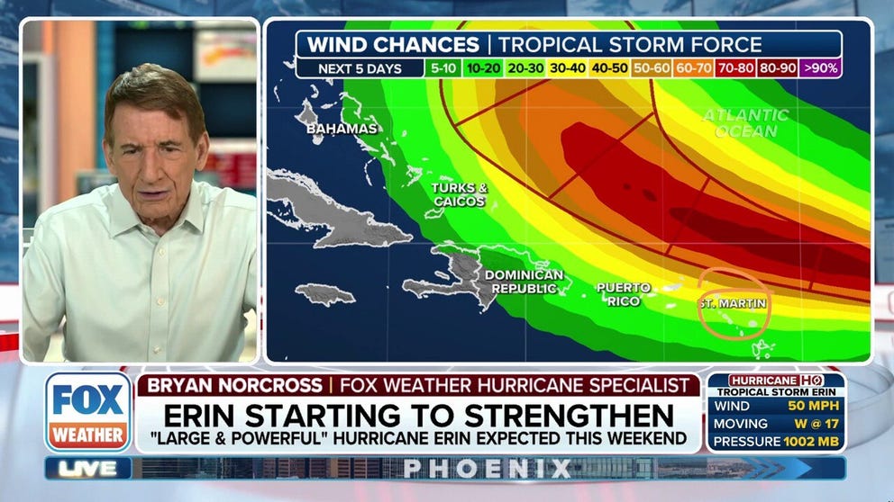
The consensus of the long-range computer forecasts has shifted a little closer to the US East Coast, but the worst of the storm is still expected to remain well offshore.
Erin is forecast to be an intensifying hurricane as its center passes just north of Puerto Rico and the nearby islands over the weekend. The question has always been: will the turn north be sharp or more of a gradual arc that will bring the center closer to Cape Hatteras and perhaps even Cape Cod? Both stick out into the ocean, of course.
The consensus of the latest forecasts is that the center will pass offshore, but these days we look at plausible scenarios presented by a set of models and not just specific, deterministic computer simulations by the Euro model or the US GFS model.
WATCH FOX WEATHER ON FACEBOOK LIVE

This is satellite imagery of Tropical Storm Erin.
(Bryan Norcross / FOX Weather)
There is a plausible scenario that a strong Hurricane Erin's center will track close enough to Eastern North Carolina and New England to do more than just brush the coast next Wednesday and Thursday. That's not the most likely scenario, but it can't be completely ruled out at this point. The average errors of the computer forecasts six or seven days in the future are 300 miles or more, which would encompass a track near the coast.
Tropical Storm Erin has strengthened a little from yesterday, but not much. The storm is just beginning to track over water above 80°F, and much warmer water is ahead. That means there will be more energy and more moisture for the system to tap into. The moisture helps push away the residual dust and dry air, which is still wrapped into the circulation.
The National Hurricane Center forecast continues to call for an intensifying storm, reaching hurricane strength before it arrives over the waters north of Puerto Rico and the northeastern Caribbean islands over the weekend. The shift in the models somewhat closer to the US East Coast next week has not affected the thinking about Erin's track near the islands.
The storm is expected to be close enough to produce gusty squalls and strong bands of rain from a tail of moisture feeding into the strengthening hurricane. Everybody in the affected islands should stay in close touch with their local forecast late in the week and through the weekend.
The current thinking is that Erin will be at Category 3 strength as it turns north offshore of the Bahamas on Monday and Tuesday. The dip in the jet stream that will provide a path north will also contribute to the system growing in size.
As we saw with Hurricane Helene last year, large systems transfer significant energy into the ocean, causing powerful swells to radiate from the storm. Strong currents along the coast and into waterways plus large waves in many locations will impact the coastline in the Southeast early in the week and spread north as the storm parallels the coast.
Beach and boating conditions will likely become dangerous. Be aware.
By tomorrow, Erin should be well enough developed that we can have more confidence in the computer forecast models, and hopefully they'll settle down. Remember the rule: forecasts for disorganized or just organizing storms are always subject to larger errors and likely to change.
There's nothing to do now except stay informed if you live along the coast from the Carolinas to New England.
This graphic shows tropical activity in the Atlantic Basin.
(Bryan Norcross / FOX Weather)
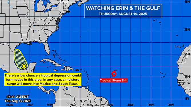
In the Gulf
A disturbance with a slug of tropical moisture that crossed Mexico's Yucatán Peninsula yesterday is in the Bay of Campeche in the extreme southwestern Gulf. The National Hurricane Center has its odds of developing into a tropical depression in the low range. It's not going to have much time today over water.
It will likely move over the Mexican coast and spread moisture into South and south-central Texas tomorrow. Even if it were to develop into a tropical depression, the impact on land wouldn't be significantly different.
In the pipeline
Behind Erin, there are a number of other disturbances. Some of the computer forecasts indicate one or the other will organize in the next week or so, but there is no consensus. In any case, we'll have plenty of time to see if anything develops.