Bryan Norcross: Hilary impacts Southern California beginning this weekend while Atlantic is slowly waking up
The biggest threat appears to be from the tropical moisture being pulled out of Hurricane Hilary spreading over the mountains and deserts of Southern California and the Southwest

FOX Weather is your Hurricane HQ, streaming free 24/7.
(FOX Weather / FOX Weather)
Updated on Thursday at 10:00 a.m.
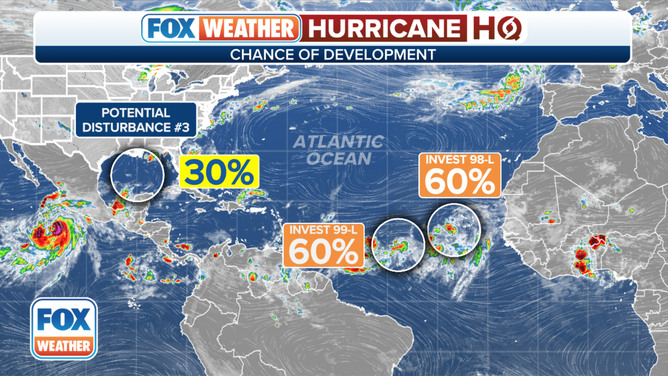
Two tropical disturbances on the far side of the Atlantic and a disturbance that’s forecast to reach the Gulf of Mexico all have the National Hurricane Center’s attention. None of them is expected to be a significant threat to the U.S. or surrounding areas, but we’ll watch Invest #99L to be sure it turns north before reaching the Caribbean Islands. The important tropical threat is from Hurricane Hilary in the Pacific. Hilary’s initial effects are expected to reach Southern California over the weekend.
The two tropical disturbances in the eastern Atlantic are quite close to each other, but for now, it looks like they will be able to operate independently without limiting each other’s ability to develop. They are both forecast to plow into Saharan dust, which spreads across the Atlantic to their north. As always, this should limit their ability to strengthen to one degree or another.
The tropical weather outlook for the Atlantic Ocean.
(FOX Weather)
Currently, the Tropical Disturbance closer to Africa – officially called Invest #98L – is the larger of the two disturbances. Large systems can take longer to consolidate and intensify, but they can also carry more moisture. In any case, the strong consensus is that this disturbance will turn north into the Atlantic. The National Hurricane Center is giving it a medium chance of becoming at least a tropical depression before dusty air and hostile upper winds take their toll.
The westernmost Tropical Disturbance – officially Invest #99L – is about midway from Africa to the Caribbean. It is forecast to head in the general direction of the northeastern Caribbean islands. Current computer forecasts turn it north before it reaches the islands, but it appears that at least part of the steering could be coming from its proximity to the larger disturbance to its east. It’s also possible that the system just to west could become more dominant.
![The latest on Invest 98L in the Atlantic Ocean.]() Image 1 of 3
Image 1 of 3The latest on Invest 98L in the Atlantic Ocean. ( )
![The latest on Invest 99L in the Atlantic Ocean.]() Image 2 of 3
Image 2 of 3The latest on Invest 99L in the Atlantic Ocean. ( )
![The latest on a potential tropical disturbance in the Gulf of Mexico.]() Image 3 of 3
Image 3 of 3The latest on a potential tropical disturbance in the Gulf of Mexico. ( )


The bottom line is, the forecast for Invest #99L is more uncertain than normal. Everybody in the northeast Caribbean islands should stay aware of the forecasts for next week to be sure it turns north. The National Hurricane Center also gives this system a medium chance of developing into at least a tropical depression.
Near the Dominican Republic, there is a weak tropical disturbance that is expected to move over the Florida peninsula over the weekend and then into the Gulf. There’s a slight chance it could organize into a tropical depression before it reaches the Texas or Louisiana coast Monday or Tuesday.
It will be moving along at a pretty good clip, pushed by the flow around the giant high-pressure heat dome over the central U.S. That means it won’t have much time over the extremely warm Gulf waters. As a result, the National Hurricane Center pegs the development odds as low.
In any case, it looks increasingly likely that the system will bring beneficial rain to Texas and possibly parts of the northern Gulf coast, which should break the heat wave, at least temporarily, next week. The net net looks positive at this point.

The latest information on Hurricane Hilary.
(FOX Weather)
In Southern California, there is increasing concern for significant impacts from Hurricane Hilary. Hilary is forecast to get pulled north by a river of air between the heat-dome high-pressure system over the central U.S. and a low-pressure system off the coast of California.
For the next few days, Hilary will be over warm Pacific water and under upper winds that are conducive for strengthening. The National Hurricane Center is forecasting it to intensify into a Category 4 hurricane well offshore of the central Mexican coast.
Before it reaches the vicinity of Southern California, however, it will pass over much colder water, which should cause it to weaken significantly. It’s unclear if the core of the storm will make landfall over Baja California or stay over the ocean until it reaches the Southern California coast. The sooner it hits land, the faster the peak winds will decrease.
In either case, however, gusty winds coming over the mountains could affect most of Southern California early next week. The valleys and passes where winds are extra gusty in a regular Santa Ana event are most likely to be impacted. Though in this situation, the wind will be wet, not unusually dry.
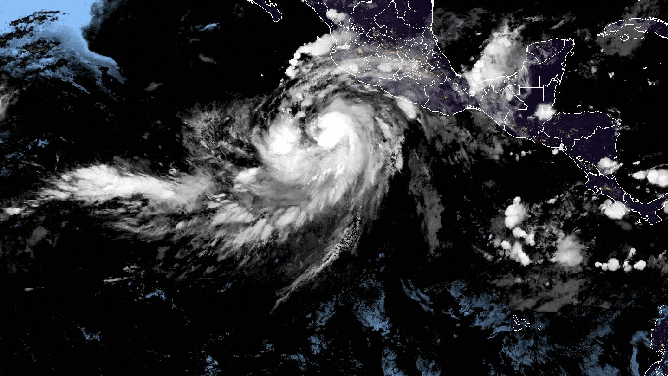
An animated loop of Hilary as it spins off the southwestern coast of Mexico on Thursday, August 17, 2023.
(NOAA / NOAA)
The biggest threat appears to be from the tropical moisture being pulled out of Hurricane Hilary spreading over the mountains and deserts of Southern California and the Southwest. Where the most intense band of moisture will set up is not knowable yet, but the combination of tropical moisture and terrain that does not normally experience air this moist is a recipe for problems.
Flash flooding could be dangerous in the low deserts, the east-facing mountains, and possibly over most of the Southland.
Everybody in Southern California should stay up to date on the latest forecasts over the weekend and into next week. This will be a multi-day event.
On the current schedule, the moisture should begin feeding into California on Saturday and steadily increase into Monday. The peak inflow of moisture would be late Sunday into Monday.
If you haven’t done it, download the FOX Weather app now. You’ll get alerts issued by the National Weather Service, plus you can stream FOX Weather by touching "Watch LIVE" in the upper right of the app’s home screen.
Be informed before you head out.