High concern for significant hurricane hit in Florida from strengthening Tropical Storm Ian
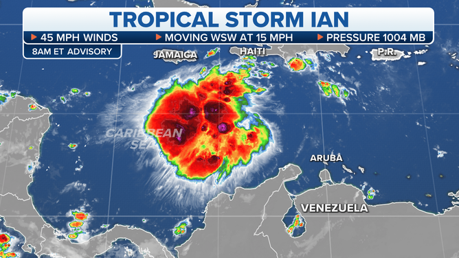
Between today and Monday, the storm will be moving across the Caribbean toward western Cuba. The environmental pattern will steadily become more conducive for the system to organize and strengthen today, but Sunday and Monday pattern is forecast to be extremely supportive of hurricane development.
The podcast Tracking the Tropics with Bryan Norcross is now available to stream.
(FOX Weather)
Updated at 8:15 a.m. ET
Tropical Storm Ian formed out of the disturbance we have been following in the Caribbean Sea. Between today and Monday, the storm will be moving across the Caribbean toward western Cuba. The environmental pattern will steadily become more conducive for the system to organize and strengthen today, but Sunday and Monday pattern is forecast to be extremely supportive of hurricane development.
Ian should miss Jamaica to the south, but people in the Cayman Islands should be ready for Ian to be a hurricane when it passes over or near the islands.
There are two key pieces of the atmospheric puzzle that the computer forecast models – which are really simulations of the atmosphere – have to predict. Where and how strong is the storm going to be Sunday into Monday? And how strong is the dip in the jet stream going to be that will try to scoop it up, to one degree or the other?
The biggest differences in the computer forecast models are related to the scoop. Models that show the jet-stream dip extending far into the Gulf show the storm being pulled north and quickly arcing toward Florida.
The forecast simulations that show a weaker scoop take the storm farther north along Florida's Gulf coast or into the Panhandle.
The National Hurricane Center forecast splits the difference between these possibilities, which is, on average, the best approach. Both options, which are represented by either side of the cone, seem plausible at this time.
By tomorrow, when Ian is in a more supportive environment for strengthening, the storm should be better defined, and hopefully the models will be past this development-stage uncertainty. Normally, better developed storms yield better more consistent forecasts. We also will, hopefully, see predictions for the dip in the jet stream more consistently simulated by the various computer forecast models.
HOW TO WATCH FOX WEATHER ON TV
The entire state of Florida is threatened by this storm. The eastern Panhandle is just now in the cone, but that's been because the cone only goes out 5 days. If the storm tracks farther north, it will get there beyond the cone's time frame. Ian would be more inclined to go that way if the jet stream dip doesn't pick it up.
Any track that curves from the Gulf into the Florida peninsula is extremely dangerous for locations near the eye and well to the south where the Gulf water is driven onshore and into bays, rivers, and inlets. Because we don't know where the landfall point might be, we can't be sure of the high-danger zone. But the west coast of Florida is one of the most susceptible places on the U.S. coast to life-threatening storm surge.
(FOX Weather)
The challenges in the Keys are well known since there is the only road out if people have to evacuate. Everybody there should stay in close touch with local officials as they navigate the difficult decisions that have to be made.
In the Miami to Palm Beach metropolitan area, a disruptive storm is still possible. Recall all the problems after Hurricane Irma five years ago, and that was essentially a tropical storm on the southeast Florida coast. And if Ian stayed on the right side of the cone, however, the scenario would be closer to Hurricane Wilma in 2005, which most people remember as scary and damaging. It was only a Category 1 in Miami-Dade and a Category 2 in parts of Broward and Palm Beach Counties. Most scenarios with Ian, however, would be less severe than Wilma.
The Wilma reminder applies to Orlando and other locations along the east coast of Florida as well.
This is a time to know what you're going to do tomorrow and Monday if the storm is forecast to come your way. People inland have to ready to lose power. People near the coast need to know their evacuation requirements. Have a good plan. Get ready just in case.
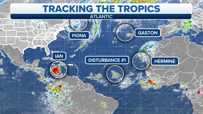
Hurricane Fiona has merged with a northern system, and the combo storm is battering Atlantic Canada with hurricane-force winds. Widespread damage has already occurred, and the bad weather will continue today.
Otherwise Tropical Storm Gaston, Tropical Storm Hermine, and a Tropical Disturbance all have a short time left before they die out.
Nothing else is pending right away, though we'll keep an eye to the south. As we approach October, most of the systems originate or strengthen in or near the Caribbean.
FOX Weather Hurricane Specialist Bryan Norcross has a podcast, Tracking the Tropics with Bryan Norcross, available now on FOX News Audio. You can get it on your device by clicking here.