Bryan Norcross: Future Tropical Storm Lee, now Invest 95L, could eventually become strong hurricane
Residents of Puerto Rico and the surrounding islands should stay well-informed over the next few days to be sure the system behaves as the computer forecasts indicate and stays well offshore.

FOX Weather is your Hurricane HQ, streaming free 24/7.
(FOX Weather / FOX Weather)
UPDATED Tuesday at 9 a.m. ET
The Tropical Disturbance (officially tagged Invest 95L) we have been following in the central tropical Atlantic is on the cusp of developing into a tropical depression or Tropical Storm Lee. The strong consensus of the various computer forecasts is that the system will organize and intensify as it tracks toward the open waters just north of the northeastern Caribbean islands.
Notice that the red potential development area from the National Hurricane Center is smaller than it has been. This reflects the NHC forecasters’ certainty that the system will develop very soon.
The atmospheric conditions appear very conducive for soon-to-be-Lee to intensify into a hurricane over the next several days, especially when it gets to the waters north of the Caribbean and east of the Bahamas over the weekend.
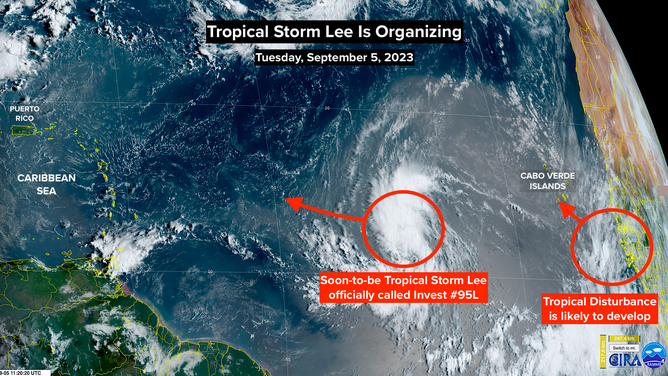
NOAA satellite imagery of soon-to-be Tropical Storm Lee.
(NOAA)
Residents of Puerto Rico and the surrounding islands should stay well-informed over the next few days to be sure the system behaves as the computer forecasts indicate and stays well offshore. In any case, strong ocean swells and fringe effects will be felt in the islands.
In the long range, the system is expected to stay well off the Southeast U.S. coast, although there is some chance of effects being felt in New England or Atlantic Canada. It’s too early to know for sure. That would be toward the end of next week. In any case, very large waves and high seas seem likely.
Lee looks to become a classic, large Cabo Verde hurricane operating over the peak days of the hurricane season. This is the most dangerous type of tropical system, so it deserves watching carefully until we’re 100% sure it’s staying away from land.
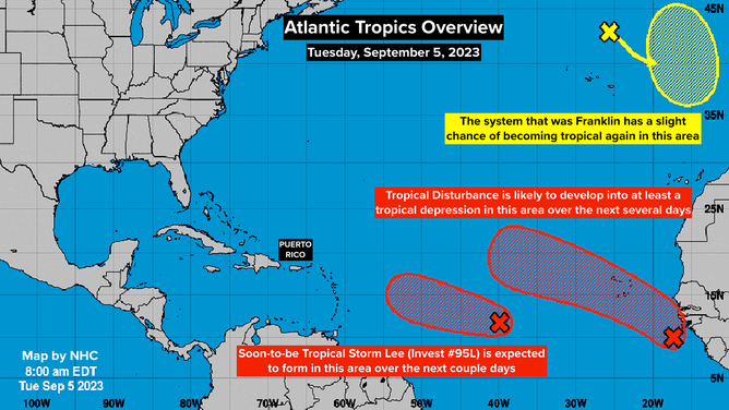
Tropical Atlantic overview on Sept. 5, 2023.
(NOAA)
Behind soon-to-be Lee, a Tropical Disturbance near the African coast also looks likely to develop. Regardless of whether it organizes by the time it gets there, the system will likely bring gusty, squally weather to the Cabo Verde Islands. Once it passes the islands, it’s likely to move out to sea. If it gets a name, it will be Margot.
In the northeastern Atlantic, the non-tropical system that started life as Hurricane Franklin is forecast to track back over warm waters off the coast of Portugal. The National Hurricane Center gives it a slight chance of becoming at least quasi-tropical again. It will keep the name Franklin if that happens. There is no indication it would be very strong if it survives long enough to make landfall.
Otherwise, the Gulf and the Caribbean look calm – a good thing for this time of year.