Fiona to impact Puerto Rico, nearby islands; future track after Caribbean very uncertain
Widespread rain amounts of 4 to 8 inches are forecast with up to 12 inches in Puerto Rico due to the higher elevations. Mudslides and local flooding are a threat, which will exaggerate as the soil further saturates. The rain may still be a threat there on Monday as well.
The podcast Tracking the Tropics with Bryan Norcross is now available to stream.
(FOX Weather)
Updated at 9:20 a.m. Eastern
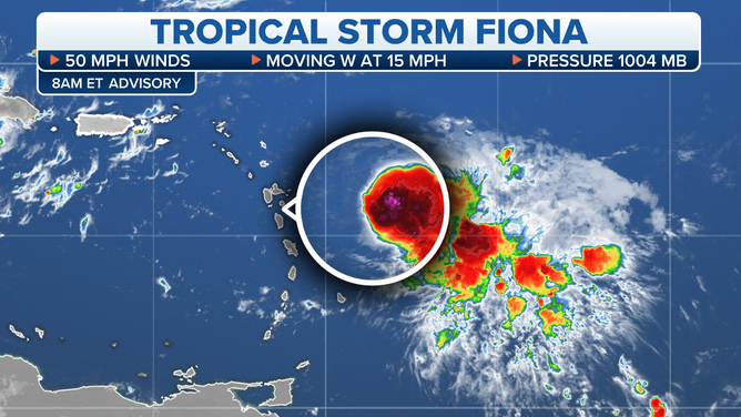
Tropical Storm Fiona continues to struggle against dry air and strong upper winds, but it will still impact the northeastern Caribbean islands – from the island of Guadeloupe north – late today, then the Virgin Islands and Puerto Rico over the weekend.
Winds will be very gusty in heavy squalls, especially in areas exposed on the east and south sides of the islands to the north of Fiona's track. Gusts in higher elevations could reach hurricane strength.
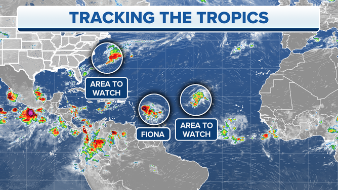
The circled areas are being monitored in the Atlantic.
(FOX Weather)
Fiona has been tracking a bit south of the forecast, which will expose more of the islands to high winds since all of the strongest winds in the circulation are on the north and east sides of the center.
Widespread rain amounts of 4 to 8 inches are forecast with up to 12 inches in Puerto Rico due to the higher elevations. Mudslides and local flooding are a threat, which will exaggerate as the soil further saturates. The rain may still be a threat there on Monday as well.
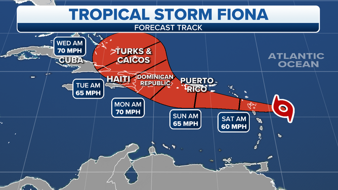
When Fiona reaches the Caribbean, its forward speed is forecast to slow down a bit. It won't be getting as much of a push from high pressure to the north. This slowdown might allow it to consolidate and strengthen as it gathers more moisture around the center. The overall environment is also forecast to become somewhat more conducive for development.
Then, as Fiona is pushing toward the Dominican Republic on Sunday, the forecast becomes quite murky.
Tracking Tropical Storm Fiona.
(FOX Weather)
First, we can't be sure of the Fiona's intensity on Sunday. There are a variety of factors in play. But the intensity is important because the strength of the storm and its future track are interrelated.
A strong dip in the jet stream will set up along the East Coast of the U.S. and over Florida late in the weekend and early next week. In most scenarios, that dip will scoop up Fiona and pull it north. The question is, when will that happen?
If the storm is reasonably well developed when it passes Puerto Rico, the dip should be able to grab Fiona then and take it north, perhaps through the Mona Passage between Puerto Rico and the Dominican Republic. It would then likely develop into a strong storm in the Atlantic well offshore of the Bahamas.
If however, Fiona remains reasonably weak, it's likely to move farther west before turning north, meaning it would be dragged over the tall mountains of the Dominican Republic or Haiti or even eastern Cuba. Fiona could re-form after its trip over the mountains, or it could dissipate. But whatever's left of the system could be over or near the Bahamas and loser to the East Coast of the U.S.
HOW TO WATCH FOX WEATHER ON TV
When storms pass over those mountainous islands, the results are unpredictable, which makes it impossible to know what state Fiona will be in if it takes that track.
When and if the storm reaches the Atlantic, and if it still has a circulation, the computer forecast models indicate a weather pattern conducive for redevelopment over the Atlantic waters. So everybody in the Bahamas and on the U.S. East Coast, including in Florida, should stay informed.
There's a small but not zero chance that a very weak Fiona ducks under the scoop and continues west south of Cuba. The jet-stream scoop is forecast to be quite strong, however, so that appears to be the least likely scenario at this point.
The projected path and intensity of Tropical Storm Fiona.
(FOX Weather)
There's a rule that forecasts for disorganized systems and systems that interact with mountainous islands often have larger errors and are subject to change. That certainly applies here.
It appears it will be late in the weekend before we have a better idea what Fiona might do, when we see how strong it gets and how far south and west it tracks through the Caribbean. At that time we might know to what degree the mountainous islands will come into play.
Elsewhere, the National Hurricane Center is making note of a non-tropical disturbance off the coast of the U.S. and a disorganized tropical disturbance in the central Atlantic. Both have a slight chance of developing as they move into the open ocean. Neither is a threat to land.
None of the systems coming off of Africa appear to be an immediate threat to develop.
FOX Weather Hurricane Specialist Bryan Norcross has a podcast, Tracking the Tropics with Bryan Norcross, available now on FOX News Audio. You can get it on your device by clicking here.