

Bryan Norcross: Tropical Storm Moke's rains arrive in Hawaii late tonight, plus an Atlantic system to watch
The National Hurricane Center is forecasting 5 to 10 inches of rain across Hawaii's Big Island with some areas receiving 15 inches. Flash flooding and mudslides will once again be a threat.
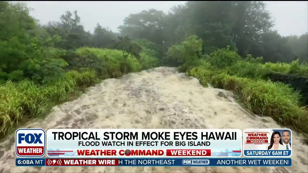
Tropical Storm Moke forms, threatening tropical downpours and flash flooding in Hawaii
Tropical Storm Moke is heading near the Hawaiian Islands, bringing another round of heavy rain and flooding just a week after deadly Hurricane Lala slammed the Big Island. The National Hurricane Center is forecasting 5 to 10 inches of rainfall, with some areas receiving up to 15 inches. Stay with FOX Weather for the latest LIVE coverage in Hawaii from Senior Correspondent Robert Ray.
Updated at 9:15 A.M. ET on Saturday, August 22nd
34 YEARS AGO TODAY
At 5:00 AM August 22, 1992, Andrew became a 75-mph hurricane. That morning, we had no idea, of course, that it would make landfall in South Florida exactly 48 hours later.
The forecast early that Saturday morning still called for the storm to turn north in the general direction of Central or North Florida. Although the National Hurricane Center discussion mentioned the possibility of Andrew tracking farther south and impacting the Northern Bahamas.
We didn't take a hurricane forecast as literally back then as we do now. The storm was heading in the general direction of the east coast of Florida, and it felt like a threat to South Florida even though the dots on the map weren't aimed directly at us.
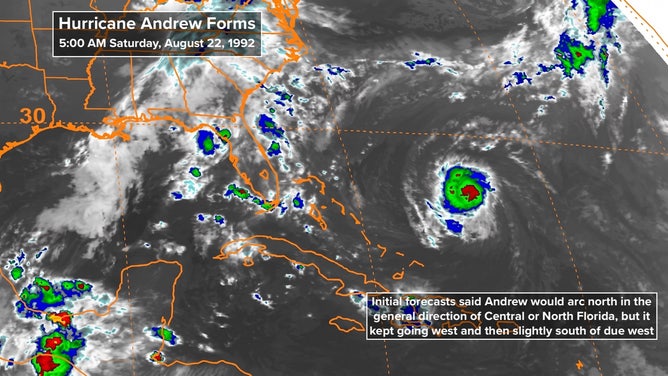
Satellite view shows when Hurricane Andrew formed in August 1992.
(FOX Weather)
That Saturday was the first time that many people in Greater Miami heard that there might be a hurricane problem. Some people responded right away, but most decided to wait and see if the threat was real.
At 11:00 AM, the track shifted south. It was now aimed just north of Palm Beach and intensification was forecast. A Hurricane Watch was issued for the Bahamas.
At 5:00 PM, the forecast track shifted south even more. Andrew was refusing to turn north. Every check-in from the Hurricane Hunters reported a storm heading due west. And it was speeding up. The bull's-eye was now Boca Raton. Hurricane Andrew was scheduled to make landfall on Monday afternoon. A Hurricane Watch was issued for Central and South Florida from Titusville east of Orlando to Key West. Top winds were up to 100 mph.
At 11:00 PM that Saturday night, Hurricane Hunters reported 110 mph winds and more strengthening was forecast. Andrew was now heading south of due west. The new target was southern Dade County. The updated forecast arrival time was Monday morning.
From then on, the forecast didn't move, and it turned out to be essentially perfect. But we didn't know that, of course. All of South Florida felt the threat equally.
Sunday would be a day of action.
TROPICAL STORM MOKE
Moke will pass well south of Hawaii, but its moisture will spread across the islands beginning late tonight or early tomorrow. The impacts should be manageable, except on the southeast-facing slopes of the Big Island – the same slopes that were devastated by Hurricane Lala.
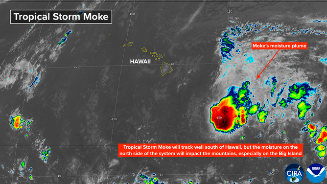
Satellite view shows Tropical Storm Moke's latest location in the Pacific.
(FOX Weather)
The National Hurricane Center is forecasting 5 to 10 inches of rain across Hawaii's Big Island with some areas receiving 15 inches. Flash flooding and mudslides will once again be a threat.
Enhanced rainfall is forecast across all of the Hawaiian Islands, although much less. The prediction is generally 1 to 2 inches with up to 4 inches falling on the eastern slopes on Maui.
LATEST NEWS ON TROPICAL STORM MOKE
The storm will be far enough south that wind won't be an issue except at the high elevations and on the downslope side of the gaps and passes, especially on the Big Island.
Moke is forecast to weaken later in the weekend and head into the open ocean.
ELSEWHERE IN THE PACIFIC
Tropical disturbances that can't get going in the Atlantic are forecast to light up the Eastern Pacific. The National Hurricane Center is noting three areas for potential development. There are so many in the same area, it's hard to keep them straight.
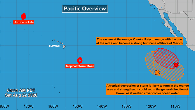
Map view of activity in the Pacific basin
(FOX Weather)
The top two orange and red areas will likely merge into one strong hurricane as it tracks north well offshore of Mexico. The impact on land will be big surf.
The only slight chance of an eventual threat to land appears to be from a system forecast to begin developing toward the end of next week in the orange area farthest south. Some long, long-range forecasts eventually take the system in the general direction of Hawaii. Obviously, the storm hasn't even begun to form, so any forecast has to be taken as a big maybe.
IN THE ATLANTIC
A robust disturbance is forecast to move off Africa on Monday. Most computer models develop it over the tropical Atlantic.
The large yellow potential development area stretching across the tropical Atlantic means the National Hurricane Center gives it low odds of organizing somewhere in that zone during the next week.
LATEST NEWS ON THE ATLANTIC AREAS TO WATCH
Some long, long-range computer forecasts show the system turning north and becoming quite strong. It will have to fight off dusty air and El Niño-driven upper winds, but if it runs that gauntlet and turns north into the Atlantic, it should find greener pastures. Bermuda might have to watch it down the road.
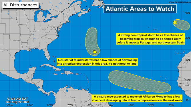
Breakdown of the Atlantic areas to watch for potential development.
(FOX Weather)
There's nothing really to think about now since the disturbance is still over Africa.
The two northern yellow potential development areas mean tropical systems could form but the odds are low.
The system in the middle of the Atlantic is a small low-pressure system that has a slight chance of becoming a tropical depression. Whether it develops or not, it could bring some rain to Bermuda on Monday.
The system near Europe is a strong non-tropical system. If it can shed its front and gain some tropical characteristics, it will be named Dolly. In any case, it will bring nasty weather to Portugal and northwestern Spain.
Even in an El Niño year, some storms are likely to develop. So we have to pay attention like always.